Ponderosa Pine Distribution(1) (PDF)
File information
This PDF 1.4 document has been generated by Adobe InDesign CS4 (6.0.6) / Adobe PDF Library 9.0, and has been sent on pdf-archive.com on 03/08/2012 at 04:53, from IP address 66.188.x.x.
The current document download page has been viewed 1513 times.
File size: 9.4 MB (9 pages).
Privacy: public file


File preview
Distribution of the Ponderosa Pine
Tree in the Black Hills Near
Spearfish, SD
Dustin Heidinger
November, 2011
i
Table Of Contents
Intro....................................................................................................................................... 1
Elevation............................................................................................................................... 2
Geology................................................................................................................................. 3
Soil Units.............................................................................................................................. 4
Human Activity..................................................................................................................... 5
Discussion and Conclusion................................................................................................... 6
Works Referenced..................................................................................................................7
Reference Maps
Spearfish, SD and Black Hills National Forest..................................................................... 8
Elevation and The Ponderosa Pine........................................................................................ 9
Extent of Shale Belt Near Spearfish, SD............................................................................... 10
Favorable and Unfavorable Soil Units of the Ponderosa Pine.............................................. 11
Land Uses Near Spearfish, SD.............................................................................................. 12
ii
Intro
The Ponderosa Pine ( Pinus ponderosa )
The Black Hills of western South Dakota are a small isolated chain
of mountains. The mountain range is commonly refered to as “An island
of trees in a sea of grass”. Rolling hills, rocky cliffs, and outcroppings
characterize this unique landscape in the north western plain region of the
United States. The majority of the Black Hills are owned by the United
States National Park Service. The Black Hills national forest stretches over
three hundred thousand acres of western South Dakota with a small portion reaching across the border in to Wyoming.
The fact that the Black Hills compose a region of dense coniferus forests that is surrounded by expanisve grasslands makes it an interesting place to examine the conditions that allow these conifers to do
so well. The Ponderosa Pine (Pinus ponderosa) is by far the most dominant and abundant coniferus tree in the Black Hills. This particular pine
is a native species found throughout the American west. These pines can
be found in 16 states as well as British Columbia. They are found up and
down the pacific coast and reach all the way east in to the Black Hills of
Ponderosa Pine
South Dakota. The trees can reach up to 160 feet tall, range anywhere from 75 to 250 years old at maturity, and have been found to live up to 600 years (NCRS, 2004). The Ponderosa is a resilient tree, it can survive extreme heat and can withstand the harsh winters commonly seen in its growing range.
As illustrated by Figure 1, the specific study area lies south of the city of Spearfish, SD and extends in
to the northern part of Deadwood, SD. A large part of the study area lies within the Black Hills National Forest.
The Ponderosa Pine
is a very hardy tree
with widespread distribution across the western United States. The
Black Hills represents
the eastern boundary
of this particular pine
species’ reach. Although it is capable of
growing at most elevations, in a variety of
soil types, and on almost any slope aspect,
there are factors that
determine where it can
be found. In this report
conditions are examined, both favorable
and unfavorable, and
their relative importance in the distribution of the Ponderosa
Figure 1. Area surrounding Spearfish, SD. Including the extent of the Ponderosa Pine Forest and the boundaries of Black Hills National Forest.
Pine is discussed.
1
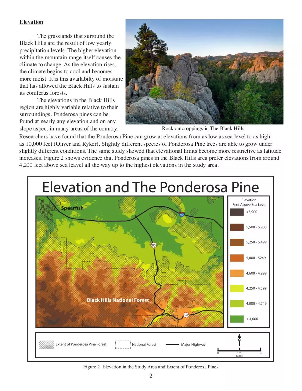
Elevation
The grasslands that surround the
Black Hills are the result of low yearly
precipitation levels. The higher elevation
within the mountain range itself causes the
climate to change. As the elevation rises,
the climate begins to cool and becomes
more moist. It is this availabilty of moisture
that has allowed the Black Hills to sustain
its coniferus forests.
The elevations in the Black Hills
region are highly variable relative to their
surroundings. Ponderosa pines can be
found at nearly any elevation and on any
Rock outcroppings in The Black Hills
slope aspect in many areas of the country.
Researchers have found that the Ponderosa Pine can grow at elevations from as low as sea level to as high
as 10,000 feet (Oliver and Ryker). Slightly different species of Ponderosa Pine trees are able to grow under
slightly different conditions. The same study showed that elevational limits become more restrictive as latitude
increases. Figure 2 shows evidence that Ponderosa pines in the Black Hills area prefer elevations from around
4,200 feet above sea leavel all the way up to the highest elevations in the study area.
Figure 2. Elevation in the Study Area and Extent of Ponderosa Pines
2
Geology
The geology of the Black Hills
is another thing that makes it unique in
its surroundings. The area is home to
an extrodinary variety of different rock
formations, as well as gold, crystals
and semi precious stones. Geology
plays a role in the structure of vegetation communities, in that it can determine if a certain area can hold soil that
is suitable for plant growth. Geologic
formations can also form physical barriers than can stop certain plants from
migrating in to an area.
In the case of our study area it
appears there are physical barriers in
A shale formation.
place that are impedeing the spread of Ponderosa pines. As Figure 3 illustrates there is a large amount of shale
present in the Spearfish area. Examination of this figure clearly shows a correlation between where the shale
is, as it stretches
across the map from
east to west, and
where the tree line
comes to a hault.
Shale is a sedimentary rock that forms
from compaction
of silt and clay
particles over time
(geology.com). Due
to the shale being
composed of these
small fine particles,
it breaks apart, causing areas of loose
chipped pieces of
rock. A shale belt
of loose pieces of
rock, as highlighted
in Figure 3, would
likely be very difficult for many plant
speices to overcome
and spread beyond.
Figure 3. Extent of Shale Belt Relative to Nearby Coniferus Forest
3
Soil Units
The type of soil present in a given area is one of the main driving factors behind what can and does grow
there. When examining the soil units that the Ponderosa tree seems to favor, they all appear to consist of deep,
well drained soils that appear on generally gradual slopes. As shown by Figure 4, the pine trees in the area of
study find a variety of soil units suitable for growth. The units in the “Favorable Soil” category include:
VCE – Virkula association, hilly. Deep, well
drained soils, gently rolling to steep soils. Found
in smooth upland divides and along drainage pathways. Slopes are smooth and can range from 6 to
30 percent.
CBE – Citadel association hilly. Consisting of
deep, well drained soils. Found in smooth upland
divides and the sides of mountain valleys and
drainage pathways. The slops in this unit are gradual and smooth and range from 6 to 30 percent.
VBF – Vancocker-Citadel association steep. This
soil series consists of steep to very steep, well
drained, deep soils. It is found on the edge of ridges and on the sides of mountain valleys. Slopes
range from 25 to 60 percent and are generally long
and smooth.
GBE – Grizzly-Virkula association, steep. Consisting of deep, well drained soils. Occurs on the
breaks along the edge of ridges and the sides of
mountain valleys. Slopes are usually long and
slow and range from 25 to 60 percent. This soil
unit is also described as well suited for timber production.
MaD - Maitland Loam. Fairly steep slopes. Good
organic material and high water availability.
Figure 4. Favorable and Unfavorable Soil Units
LaE - Lakota Silt Loam. Deep, well-drained soil.
Lower in organic material. Runoff is medium to
rapid.
Soil unit descriptions from: “Soil Survey of Lawernce County” USDA-SCS 1979
There is a clear line in which the pine forest stops. Along with the shale belt there is also the occurance of the
PbE soil unit. This unit is characterized by being well to excessively drained soil in combination with rock outcroppings. This unit is between 45-55 percent soil and 35-45 percent rock outcrop. Along with the favorable soil unit
category, Figure 4 also highlights the PbE soil unit. When presented in this manner it becomes clear that the PbE soil
type lies distincly along the edge of the coniferus Ponderosa pine forest. The placement for the treeline could be due
to a number of factors. If the treeline is influenced by the presence of this soil unit it could be due to the fact that the
slope here is a little steeper than most of the other soil units in the area that the Ponderosa is found on, or it could also
be due to the soil being excessivly drained, meaning that it may not hold enough moisture for the pine tree to thrive.
The soil survey also describes vegetation on this unit to consist of short grasses, sedges, and ponderosa
pines. It also states however that the harvesting of pines from this unit is limited due to the stands being thinner than pine stands found in higher elevations. This provides some explanation of the abrupt end to the coniferous ponderosa pine dominated forests.
4
Affects of Human Activity
Human activity has a major impact on the dynamics of any nearby forests or any other types of vegetation. A healthy, naturally functioning Ponderosa Pine forest needs periodic disturbance by way of slow moving
low intensity forest fires. These fires would clear out underbrush, and burn off new growth while only scarring
the older pines. This would result in thicker stands of older Ponderosa Pine trees over time in a naturally functioning forest.
This periodic
burning from natural
forest fires is referred
to as a forest’s “fire
regime”. Any time a
human population is
near, the fire regime
is most likely much
different, or in some
cases non-existent.
There is always the
fear that a fire could get
out of hand and possibly cause damage to a
nearby city or be harmful to human health.
This fear leads to the
halting or altering of
the natural fire regime.
Another way
that human populations
change the dynamics of
a forest is by logging
parts, or all of a forest.
Many times a forest is
cleared to make room
for grazing or agriculFigure 5. Coniferus Forest cover, natural land cover, and human activity.
tural land. Once the
trees are cleared, and
Figure 5. Land Uses in the Area of Study
cattle or other livestock
start grazing the land, it is very unlikely that the forest will be able to return to the area as long as these activities continue. In the case of the Ponderosa Pine forest in the areas south of Spearfish, it appears that this is a
very real scenario. When you examine the boundary of the forest, and compare it to land that is being used
for human activities, it becomes clear that the lines where activity end, and the forest begins are very close to
each other. In Figure 5 you can see that human activities are taking place almost everywhere the forest ends.
These activities include Pasture/Hay, which is the most common human induced land cover. Other types of
land cover due to human activity included in this category are residential areas, small grain fields, commercial/
industrial/ transportation zones, some quarrying activities, and other scattered human uses. This map clearly
shows that human activity is likely causing an effect on where the tree line stops. The Pines are also able to
spread in the higher elevations in the areas east of the city of Spearfish just south of Interstate 90.
5
Disscussion and Conclusion
The Ponderosa Pine is an abundant and widely distributed tree in the Black Hills area. It is capable of growing in
extreme heat during the South Dakota summer, and the harsh
cold winters that sweep across the great plains every year.
This tree can grow on almost any aspect, and on many different slopes. There are reasons that the tree hasn’t spread farther
east than the Black Hills. The reasons include natural factors,
as well as human induced ones.
Elevation does play a role in where the pine can be
found, it clearly prefers the higher elevations of the Black
Hills as well as the Rocky Mountains. It does not appear to
be found of shale however. Shale would pose a hard surface
for most pines to put down roots since the prescence of shalle
means slopes covered in small pieces of shale chips. Soil
types, draining ability, and organic content will have an effect
on any vegetation community. The pine in our study area
seemed to dislike the Paunsaugunt-Rock outcrop soil unit.
This could be due to a few factors. One factor could be the
steep slope, another could be due to the unit being excessivly
drained, a third reason could be the low amount of organic
material found in this unit. Human activity also plays a large
role in the structure and function of any plant community. In
the case of the Spearfish area, urbanization and conversion to
agricultural land has most likely pushed the forest edge back
and held it there.
6
Works Referenced
Geology.com. “Shale: Sedimentary Rock - Pictures, Definition & More.” Geology.com: News and Information for Geology & Earth Science. Web. Nov. 2011. <http://geology.com/rocks/shale.shtml>.
Oliver, William W., and Russel A. Ryker. “Ponderosa Pine.” Pinus Ponderosa. 2005. Web. Nov. 2011.
<http://www.na.fs.fed.us/pubs/silvics_manual/Volume_1/pinus/ponderosa.htm>.
United States. Department of Agriculture. Natural Resources Conservation Service. Ponderosa Pine. By
P. Larson and C. Larson. USDA, 2004. Print.
United States. Department of Agriculture. Soil Conservation Service. Soil Survey of Lawernce County.
Comp. R. D. Swenson. USDA, 1979. Print.
Map Data Used
Grass GIS Database
Bing
Maps
Other Photo Sources
Page i
“Black Hills Forest” Photo from- http://www.zavadsky.net/david/travel/2009-road-trip/12385-z.jpg
Page 1
“Ponderosa Pine” Photo from- http://kennybeal.files.wordpress.com/2011/06/pine4.jpg
Page 2
“Black Hills Cliffs” Photo from- http://frugallysavvy.com/wp-content/uploads/2011/06/Black-Hills.jpg
Page 3
“Shale Formation” Photo from- http://ownipolitics.com/files/2010/12/Schistes-990x6601.jpg
Page 6 “Ponderosa Pine-2” Photo from - http://upload.wikimedia.org/wikipedia/commons/f/fe/Pinus_ponderosa_15932.JPG
7
Download Ponderosa Pine Distribution(1)
Ponderosa Pine Distribution(1).pdf (PDF, 9.4 MB)
Download PDF
Share this file on social networks
Link to this page
Permanent link
Use the permanent link to the download page to share your document on Facebook, Twitter, LinkedIn, or directly with a contact by e-Mail, Messenger, Whatsapp, Line..
Short link
Use the short link to share your document on Twitter or by text message (SMS)
HTML Code
Copy the following HTML code to share your document on a Website or Blog
QR Code to this page

This file has been shared publicly by a user of PDF Archive.
Document ID: 0000042970.