Design Brief Web (PDF)
File information
This PDF 1.5 document has been generated by Adobe InDesign CS5.5 (7.5) / Adobe PDF Library 9.9, and has been sent on pdf-archive.com on 20/11/2014 at 01:43, from IP address 113.11.x.x.
The current document download page has been viewed 1064 times.
File size: 1.82 MB (26 pages).
Privacy: public file

File preview
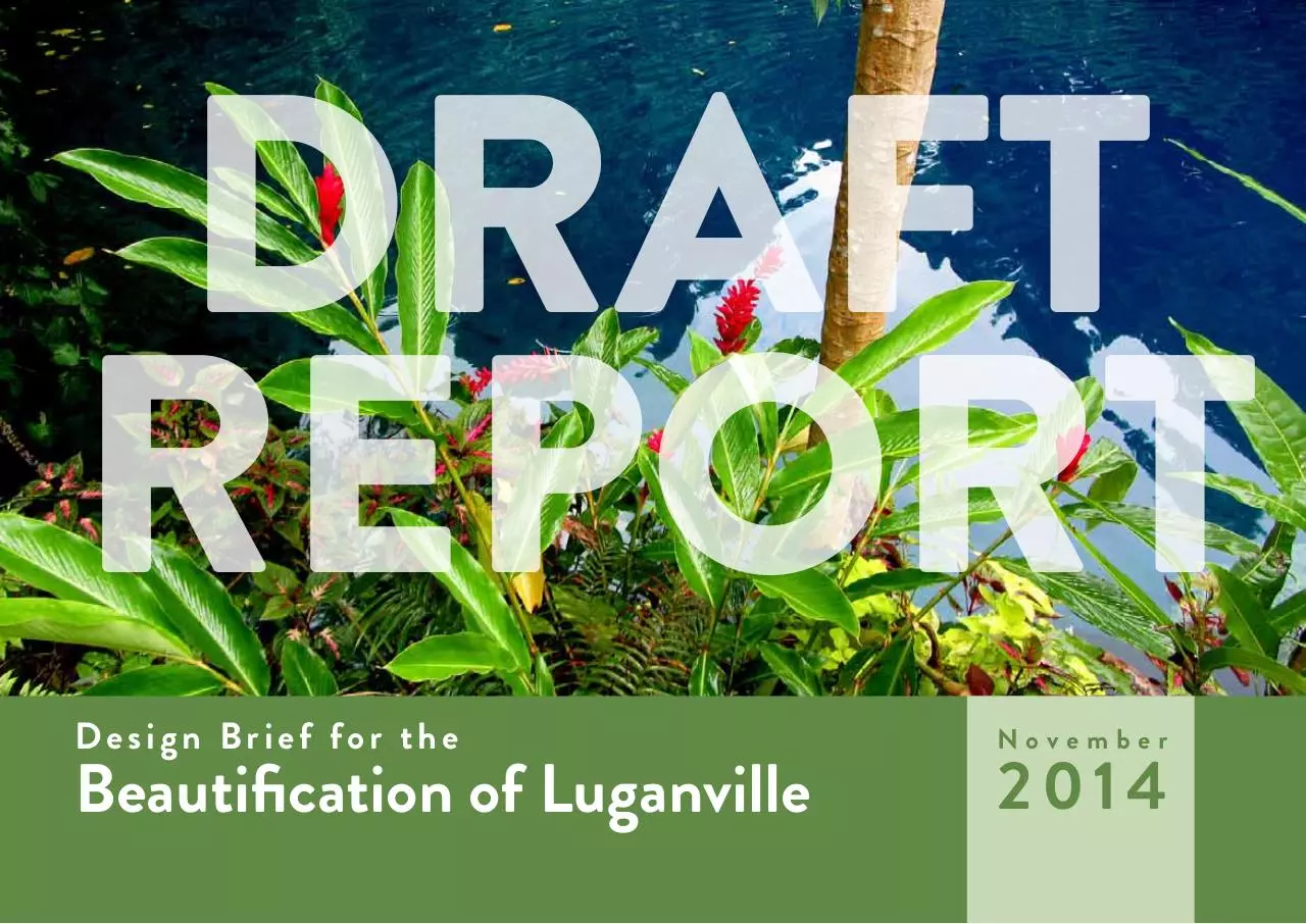
DRAFT
REPORT
Design Brief for the
Beautification of Luganville
November
2014
This Beautification Design Brief was created,
in part, at the request of the Vanuatu Department of Tourism to satisfy requirements of
the Vanuatu Strategic Tourism Action Plan
2014-2018.
It was prepared by the Luganville Beautification Taskforce through consultation with various sectors of the community.
Introduction 4
1.1 Project Inception and Overview 4
4.1 Funding Opportunities 24
1.2 Rationale for Beautification Strategy 4
Research 5
2.1 Historic Review 5
2.2 Site Assessment 6
2.3 Opportunities & Constraints 9
Schematic Plans 12
3.1 Project Vision 12
3.2 Key Areas of Development 14
3.3 Design Guidelines 21
2 Design Brief | Nov 2014
Implementation 24
Conclusion 24
Introduction
1.1 Project Inception and Overview
In 2012, Luganville established the Beautification
Committee, chaired by Ian Mano.In 2014, acting town
clerk Andrew Ala appointed Rex Issarcher to chair the
Beautification Task Force of Luganville with the purpose of forcing action on this issue.
The stated purposes of the Task Force were:
a. To carry out awareness of beautification in Luganville
b. To identify areas in Luganville to be beautified
c. To coordinate local business and stakeholders in
beautification projects, planning and implementation
throughout the municipal area
During early stakeholder meetings, it was decided
that the Task Force needed a town beautification plan
to make clear the findings of this body. Later a design
brief was deemed more appropriate, as the necessary
expertise is not available.
During this time it came to light that Luganville has
the opportunity to benefit from large-scale aid projects
funded by New Zealand and other donors. In 2013,
New Zealand Aid Programme led a forum in Port Vila
consisting of the country’s tourism industry leaders to
draft the Vanuatu Strategic Tourism Action Plan 20142018. The main purpose of this document is to prioritize large-scale projects in Vanuatu. Those representing
Vanuatu at the meeting were asked to create a list of the
10 most important projects in the country. After much
deliberation they arrived at 14. Of these 14 projects,
4 Design Brief | Nov 2014
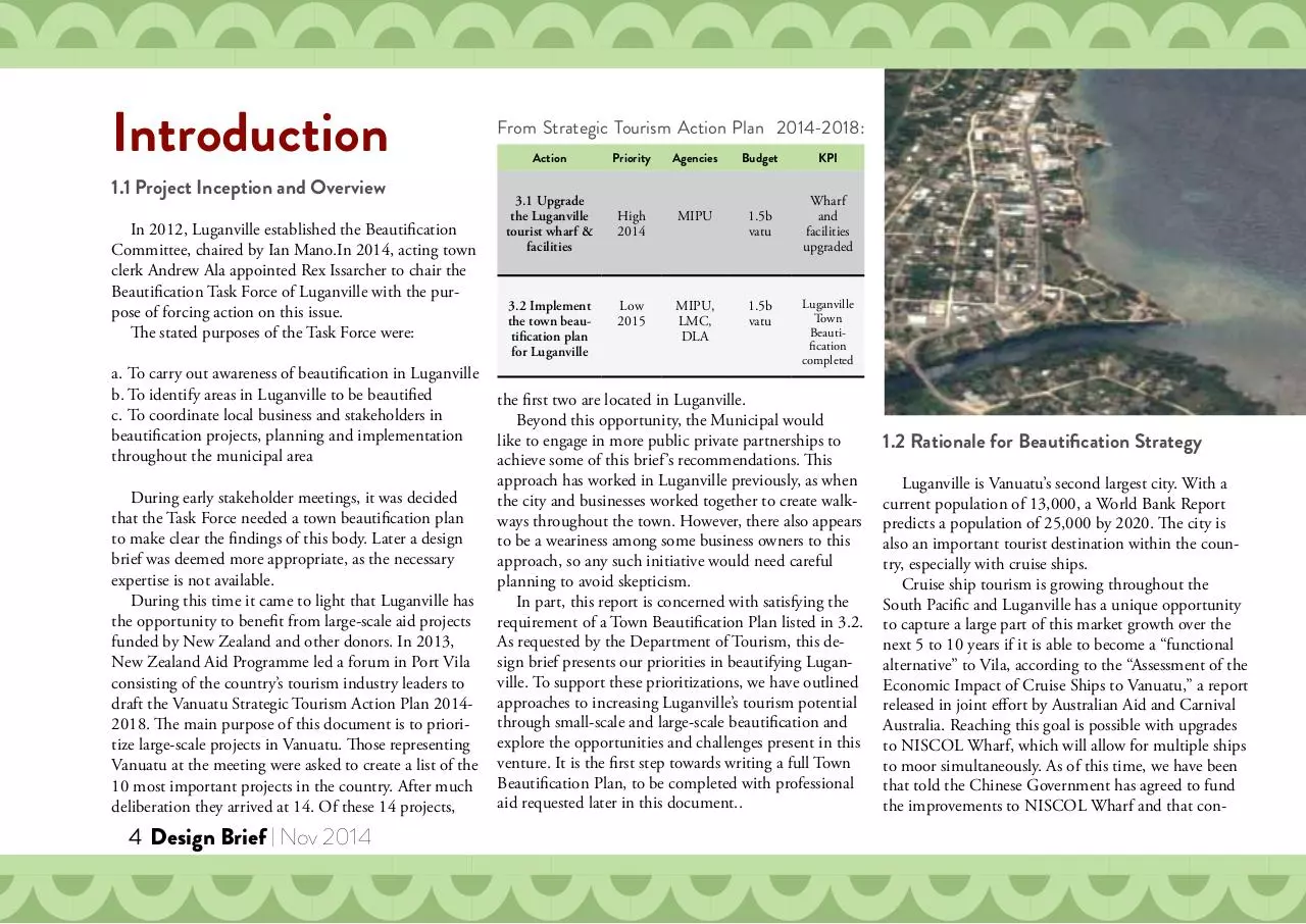
From Strategic Tourism Action Plan 2014-2018:
Action
Priority
Agencies
Budget
KPI
3.1 Upgrade
the Luganville
tourist wharf &
facilities
High
2014
MIPU
1.5b
vatu
Wharf
and
facilities
upgraded
Low
2015
MIPU,
LMC,
DLA
1.5b
vatu
3.2 Implement
the town beautification plan
for Luganville
Luganville
Town
Beautification
completed
the first two are located in Luganville.
Beyond this opportunity, the Municipal would
like to engage in more public private partnerships to
achieve some of this brief ’s recommendations. This
approach has worked in Luganville previously, as when
the city and businesses worked together to create walkways throughout the town. However, there also appears
to be a weariness among some business owners to this
approach, so any such initiative would need careful
planning to avoid skepticism.
In part, this report is concerned with satisfying the
requirement of a Town Beautification Plan listed in 3.2.
As requested by the Department of Tourism, this design brief presents our priorities in beautifying Luganville. To support these prioritizations, we have outlined
approaches to increasing Luganville’s tourism potential
through small-scale and large-scale beautification and
explore the opportunities and challenges present in this
venture. It is the first step towards writing a full Town
Beautification Plan, to be completed with professional
aid requested later in this document..
1.2 Rationale for Beautification Strategy
Luganville is Vanuatu’s second largest city. With a
current population of 13,000, a World Bank Report
predicts a population of 25,000 by 2020. The city is
also an important tourist destination within the country, especially with cruise ships.
Cruise ship tourism is growing throughout the
South Pacific and Luganville has a unique opportunity
to capture a large part of this market growth over the
next 5 to 10 years if it is able to become a “functional
alternative” to Vila, according to the “Assessment of the
Economic Impact of Cruise Ships to Vanuatu,” a report
released in joint effort by Australian Aid and Carnival
Australia. Reaching this goal is possible with upgrades
to NISCOL Wharf, which will allow for multiple ships
to moor simultaneously. As of this time, we have been
that told the Chinese Government has agreed to fund
the improvements to NISCOL Wharf and that con-
struction should begin by the early part of 2015.
The municipal must invest to make the city a friendlier environment for the increasing number of residents and tourists if Luganville
is to truly capitalize on this opportunity for increased access to tourism dollars. By beautifying the city, the municipal can expect to see
indirect and direct benefits to the small business people of Luganville.
Towards this goal we intend to activate dormant districts of town
and improve existing areas to create an easily-approachable experience for cruise ship tourists while making the city more inviting to its
residents.
Research
2.1 Historic Review
Luganville began as a settlement of Societe Francaise recruits and
was named in 1889 after Captain Lugan, commanding officer of the
“Messageries Maritimes.” For several decades the community consisted largely of plantation owners and Catholic missionaries.
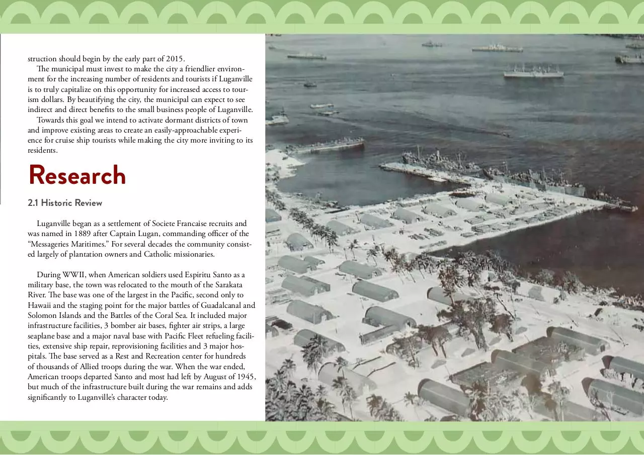
During WWII, when American soldiers used Espiritu Santo as a
military base, the town was relocated to the mouth of the Sarakata
River. The base was one of the largest in the Pacific, second only to
Hawaii and the staging point for the major battles of Guadalcanal and
Solomon Islands and the Battles of the Coral Sea. It included major
infrastructure facilities, 3 bomber air bases, fighter air strips, a large
seaplane base and a major naval base with Pacific Fleet refueling facilities, extensive ship repair, reprovisioning facilities and 3 major hospitals. The base served as a Rest and Recreation center for hundreds
of thousands of Allied troops during the war. When the war ended,
American troops departed Santo and most had left by August of 1945,
but much of the infrastructure built during the war remains and adds
significantly to Luganville’s character today.
Nov 2014 | Design Brief 5
Historic Review Con’t
2.2 Site Assessment
In the 1960s, Jimmy Stevens founded the Nagramel
movement, which wanted to succeed from the New
Hebrides. Just before Independence in 1980, the Nagramel Movement took control of Luganville, ejected
many of the Europeans, and declared Santo as the separate nation of Vemarana. Shortly, troops from Papua
New Guinea retook Luganville and Santo entered the
newly independent nation of Vanuatu. In the nearly 35
years since Independence, the nation’s focus has been
on development of the capital, Port Vila. However,
some of that focus is beginning to shift.
Main Street
6 Design Brief | Nov 2014
Main Street is the economic heart of the town. Along
this 2k stretch of road lie many of the town’s major
banks, government buildings, hotels and businesses.
Vehicle traffic is manageable, even during peak morning hours, when a pedestrian might wait a minute for
traffic to clear before crossing. The streets and sidewalks
are maintained only on an emergency basis and as a
result much of the concrete is broken and there are
several areas with open drains, dangerous to drivers and
pedestrians alike. Currently, this is the main pathway
for cruise tourists on foot when they explore the town.
Riverside Area
The Riverside Area lies along the eastern bank of the
Sarakata River, behind the Mamas’ Market and opposite to the residential area referred to as “Sideriver” by
locals. It is undeveloped Government land managed by
the municipality. There are currently several dilapidated
WWII foundations and small structures in the area that
could be repurposed as part of a history walk through
the park, though these structures may eventually fall
under control of the proposed WWII museum. Commonly, this stretch of land is used by town residents
as a place to relax and fish with hand lines. There are
footpaths that follow along the river, but no established
walkway.
Luganville Market
Also commonly referred to as The Mamas’ Market, this
is Santo’s largest local market house where vendors can
be found 24/7 selling kava, fruits, vegetables and local
seafood. Nearby are a line of stalls which offer cheap
meals to residents and tourists on a budget. Other
structures on the site include a Digicel kiosk, a public
pay-for-use toilet and a store. The market and stalls are
functional, but not aesthetically pleasing. However, UN
Women has committed to upgrading this area through
their Market for Change aid program and the Beautification Task Force is ready to assist should the need
arise.
Municipal Area
This includes the Luganville Municipal Council building, the nearby police station and recently collapsed
work shed, which was a repurposed WWII building.
There has already been some effort to beautify the
area and the Task Force believes that it is necessary to
continue to set an example. After removing the debris,
there are plans to repurpose the concrete slab where the
work shed recently stood, either as a place for holding
events or as a nursery to provide the Task Force with
plants to use in its beautification effort.
Unity Park
Commonly used for Santo’s largest community events
and a popular place for locals to relax by the sea, Unity
Park is triangle of land bordered by Main Street & the
Municipal Area, the Sarakata River and Segond Canal.
Viewable from Main Street are the most active parts
of the park including a currently vacant restaurant
building, two play grounds, one old and one new, and
a main stage used. Nearby is an open field commonly
used for football practice and other sports on weekday
afternoons. The park’s beach along Second Canal is
lined with wind-worn trees, providing nice shade. In
the center of the park are a set of stalls available for rent
where local women sell food during large events such as
Independence. Close to the shore in this area is a large,
dilapidated WWII structure. Nearer to the park’s point
are several areas to play basketball, petanque, volleyball
and football, which is heavily used by children and
adults. The point is commonly used for picnics. A dirt
road winds through the park, giving vehicular access to
the point and some interior areas. However, the park is
not a unified space, as there is no agreed upon walkway
moving through it. In some areas of the park, trees
grow naturally with no plan. In some areas, removal of
trees might create open spaces for further use in sports.
Throughout the park are benches, but they are not
placed strategically and many of them are broken.
Nov 2014 | Design Brief 7
Seawall Area
This area is defined by the unsealed road which runs
from Main Street in between Alan Power’s and Attar
down along the shore of Second Canal and then back
up to Main Street past the current Handicrafts Market.
The area currently functions as a back alley to a line of
buildings facing away from Segond Canal. The unpaved road is lined with storage containers and is used
by local stores such as Santo Hardware as thoroughfare
for transporting cargo. The bank is heavily eroded.
In some places there is nothing left but networks of
tree roots and a bit of compacted earth. All along this
stretch there are remnants of various WWII structures,
rusted beyond recognition.
8 Design Brief | Nov 2014
Proposed WWII Museum Area
The WWII in the South Pacific Museum is a privatefunded project now two years in progress. The museum
committee is searching for funding sources and is
seeking full rights to build on the land just behind the
Luganville Municipal Council building. The design of
the building is intended to provide Luganville with a
distinctive landmark and of course provide an entertainment destination to tourists and locals. Currently
the area sees little day-to-day use not provided by other
spaces within the park.
Tourist Market & Footpath Area
On the east-side of town, when Main Street reaches the
Harborview area, it makes a gentle left and ascends a
hill, becoming Canal Street. There is also a fork to the
right at this juncture which gives access to NISCOL
Wharf. On cruise ship days, this road is lined with local women selling handicrafts and purchased goods to
tourists passing by as they leave and return to the ship.
Current discussion suggests that when the upgrades
to NISCOL Wharf have been completed, the vendors
along this road and those inside the wharf will be
moved to the opposite side in an effort to make the area
more secure. Corresponding, tourists will enter and
exit through this newly opened gate. As this is a tourist’s first contact with Luganville, it is important that
something eventually be done to make the walk into
town enjoyable for those not accustomed to island life.
However, because of the uncertain nature of how this
project will progress, we currently hold development of
these areas at a low priority.
2.3 Opportunities & Constraints
Growing Sense of Luganville’s Potential
Luganville has a rich history in native culture, colonial
rule and as a WWII recreation center. Of these, the cities indebtedness to WWII is unique among the islands
of Vanuatu and so should be considered a major focus
for the development of any visual themes or designs
based on Luganville’s history.
Recently, a representative of Carnival Australia mentioned to the Department of Tourism that Luganville is
a “sleeping giant.” There is an undeniable growing sense
among stakeholders from the local to the international
level that it is Luganville’s turn for growth in Vanuatu’s
tourism economy. In recent years, at 69% approval rating, Luganville has been one of the lowest-rated ports
of call for cruise ships in the South Pacific. Recently,
however, Luganville has jumped to 83% approval rating, just below Vila’s rating of 84%.
Island Exoticism
Layout of Luganville
Opportunities
WWII History & Custom of Vanuatu
Another theme to keep in mind is the exoticism of
tropical islands. While historical and cultural accuracy
always take precedent, working to increase the presence
of island culture that tourists expect is a low cost, high
reward route to improving Luganville’s image. A prime
example of this approach is our recommendation of
increasing the number of tropical flowers in town.
Economics of Cruise Ship Tourism
Luganville’s economy is heavily based on tourism,
which is beneficial in a number of ways. It is easy to
forecast the number of tourists the city will receive in a
year and it is clear that number is increasing. The number has potential to increase even further if Luganville
can impress upcoming visitors to Luganville. Coordinating activation of the town and prioritizing projects
is simplified as the vast majority of tourists are in town
at specific times known well in advance and they all
engage the town through the same route.
Luganville has the blessing of possessing a perfect
layout for filling a morning’s walk along the seaside and
back to the cruise ship, if the necessary work is done to
activate currently undeveloped assets within the city.
Potential Revenue increases
By making the changes recommended in this report,
there are a number of easily foreseeable revenue increases to residents and the local government through job
creation and streams such as pay-for-use toilets.
Constraints
History & Infrastructure
Luganville lives its legacy. American buildings constructed during WWII dot the city in various states of
disrepair, giving it a character that many locals overlook
but is immediately recognizable to tourists. Because of
this imbalance in evaluation, it is possible that some
relics which could be repurposed as historical points of
interest will instead be torn down to make way for new
construction. It is important to remember the tourist point of view and preserve the history that makes
Luganville unique.
Lack of a Town Planner
Development of the city is currently hampered by the
lack of a town planner. The municipal is currently addressing this issue, but there are many plans which have
or will reach a bottleneck until this position is filled.
Land Ownership
There is a land ownership issue with a property adjacent to BP Wharf (area pictured left) that could
hamper development of the Seawall project. Because
of poor coordination between the Ministry of Lands
and the Ministry of Internal Affairs, a loophole allowed
for a land claim by private interests which the city has
not authorized. We recommend that the Beautification
Taskforce take on the role of coordinating the Ministry
of Lands and the Ministry of Internal Affairs in resolving this loophole and negotiating a solution that allows
for development to continue unimpeded. It is also
possible that a national law preventing the ownership
of roadways established at independence could be used
to nullify the granting of this title.
Nov 2014 | Design Brief 9
Download Design Brief - Web
Design Brief - Web.pdf (PDF, 1.82 MB)
Download PDF
Share this file on social networks
Link to this page
Permanent link
Use the permanent link to the download page to share your document on Facebook, Twitter, LinkedIn, or directly with a contact by e-Mail, Messenger, Whatsapp, Line..
Short link
Use the short link to share your document on Twitter or by text message (SMS)
HTML Code
Copy the following HTML code to share your document on a Website or Blog
QR Code to this page

This file has been shared publicly by a user of PDF Archive.
Document ID: 0000194966.