Sean Collier Final MSC 563 15SP1 (PDF)
File information
Author: Collier Family
This PDF 1.5 document has been generated by Microsoft® Word 2010, and has been sent on pdf-archive.com on 14/04/2015 at 05:46, from IP address 40.133.x.x.
The current document download page has been viewed 649 times.
File size: 1.25 MB (14 pages).
Privacy: public file


File preview
Running head: ROCK AND ROLL HIGHWAY 67
Rock and Roll Highway 67:
An Opportunity for AR in AR
Sean Shannon Collier
Fielding Graduate University
1
Running head: ROCK AND ROLL HIGHWAY 67
2
Abstract
The Rock and Roll Highway 67 was officially designated on March 20, 2009 by Arkansas
Governor Mike Beebe. Stretching through Clay, Randolph, Lawrence, and Jackson counties, the
stretch of highway hosted music legends like Elvis Presley, Jerry Lee Lewis, Roy Orbison, Little
Richard, the Everly Brothers, Johnny Cash, Billy Lee Riley, Conway Twitty, Sonny Burgess,
Chuck Berry and more during the late 50`s and early 60`s. Since being designated it has saw
growth in tourism due to the local communities’ efforts to embrace the idea. This paper looks at
the real opportunity to enhance the experiences on the legendary highway by using Augmented
Reality to create engagement and transmedia storytelling for further immersion.
Running head: ROCK AND ROLL HIGHWAY 67
3
Overview
On March 20, 2009, Arkansas Governor Mike Beebe signed legislation designating a 111
mile stretch of US highway 67 as the “Rock and Roll Highway 67.” Stretching through Clay,
Randolph, Lawrence, and Jackson counties, the stretch of highway hosted music legends like
Elvis Presley, Jerry Lee Lewis, Roy Orbison, Little Richard, the Everly Brothers, Johnny Cash,
Billy Lee Riley, Conway Twitty, Sonny Burgess, Chuck Berry and more. These artists got their
start by playing the venues up and down the legendary stretch, most of them under the Sun
Records record level. Clubs, bars, drive-ins, and high schools welcomed and nurtured the new
sound—a mixed sound of blues, country, and western that became known as Rockabilly in the
50`s and early 60`s—when Rock and Roll met hillbilly.
Present state
Since the designation the towns along the stretch have embraced the idea and many hold
yearly festivals and/or have monuments or museums commemorating the era. Walnut Ridge for
example, a 5000 population town, built a Beatles monument downtown, and then built a 100 foot
guitar walk in the shape of an Epiphone near the depot the following year (Hunt, 2012).
Pocahontas, Walnut Ridge, and Newport hold the Rock and Roll Highway 67 festival, Beatles at
the Ridge, and Depot Days yearly respectively—drawing tourists to their towns through
celebrations centered around Rock ("Rock 'n' Roll Highway 67 - Encyclopedia of Arkansas,"
2014). Green highway signs from Arkansas Parks and Tourism remind travelers along the way
repeatedly that they are travelling the legendary Rock and Roll Highway 67.
The Problem
The famous stretch of highway absolutely needs the recognition now given it, and
business`s have begun seeing the revenue, but the designation may have come a little late. Nearly
all the recognized venues or landmarks are gone, living only through memories and pictures.
Travelling the route which basically runs from Corning to Newport, people can look at maps to
find the old venues, such as the one of Randolph County in figure 1, but for most of the sites they
will only see where the famous places used to be.
Running head: ROCK AND ROLL HIGHWAY 67
Figure 1: About | Rock N' Roll Highway 67 Music Festival. (n.d.). Retrieved from
http://rocknroll67.com/about/
Tourists that travel the highway run through a string of small towns with nothing in
between but places where history used to be. The most famous locations are empty lots, such as
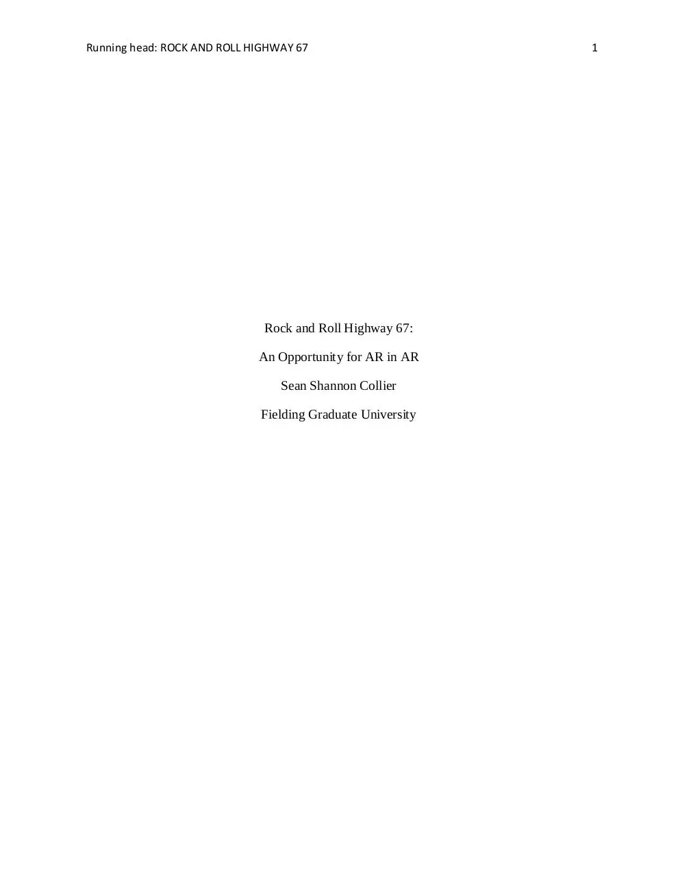
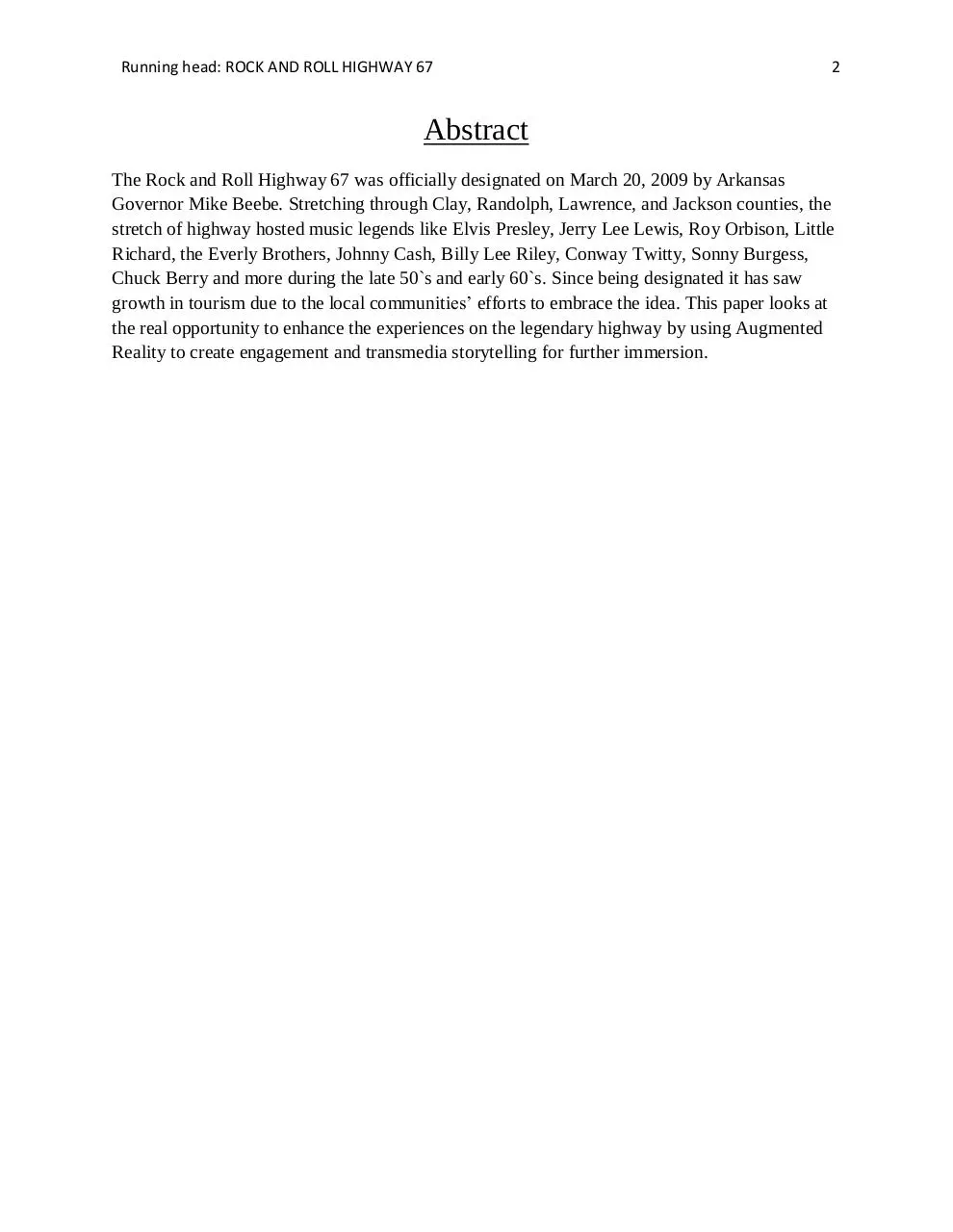
The Silver Moon, The King of Clubs, and the Skylark Drive In—shown respectively in their
present state in figures 2, 3, and 4.
Figure 2: Silver Moon - 04/05/15
4
Running head: ROCK AND ROLL HIGHWAY 67
Figure 3: The King of Clubs - 04/05/15
Figure 4: Skylark Drive In - 04/05/15
The Solution
Augmented Reality (AR) uses technology to merge computer generation with the real
world. Presently it is most used through mobile devices such as phones or tablets, but wearable
AR devices in the form of glasses are available, such as Google Glass. They are not being
embraced by the masses though, possibly due to the expense and/or their soon to be primitive
inadequacies. New breakthroughs are expected to be seen soon when Microsoft Hololens is
released this summer ("Microsoft HoloLens | Official Site," n.d.). Also, Magic Leap, in
conjunction with Google, promises to release an amazing pair of AR glasses. “The future is
5
Running head: ROCK AND ROLL HIGHWAY 67
6
fashionable eyewear, contact lenses or even bionic eyes with immersive 3D displays, conjuring
up a digital layer to "augment" reality. . .” (Farber, 2013).
Whether with handheld (now) or wearable (soon) devices, Augmented Reality is the
solution to bring the Rock and Roll Highway 67`s extensive history to the present. With AR
yesterday can be seen, heard, and shared today in real time in real places, making the forgotten
story real once more. This in turn will promote new tourism by nourishing the hungry tourist
with what they came looking for. Figures 2, 3, and 4 do not have to look so drab for example,
leaving the viewer with a blank stare and no experience to take with them. These and all the
other historic locations along the stretch can be engaging, immersive, and entertaining with
AR—making them memorable experiences worth sharing and talking about instead of the
forgettable experiences they probably are now.
How can AR be used?
Each of the towns have locations that provide engaging AR opportunities that both
directly and indirectly relate to the Rock and Roll Highway. There are also sites along the stretch
between towns that provide AR engagement opportunities as well. The following is three simple
examples of how AR can make the Rock and Roll Highway 67 a better experience for tourism.
These same tactics can be used for numerous sites both in and out of city limits throughout the
famous stretch—making it a broader experience.
Example 1: In Walnut Ridge the Beatles monument has a large area beside it that is a blank wall
(See figure 5). An AR overlay of (Beatles at the Ridge promo, 2011) would go nicely there. It
not only explains the reasons behind the Beatle monument, it shows it being crafted in sped up
time—depicting the amount of work and time that went into it in a fun and interesting way. The
video was well made but thus far has only had 1768 views and 8 comments (Beatles at the Ridge
promo, 2011).
Figure 5 Beatles Art – 04/05/2015
Running head: ROCK AND ROLL HIGHWAY 67
7
The nearby main street could be overlaid with time sequenced pictures from the past that
shows how it changed over the years but stayed surprisingly the same—as seen in figures 5
through 9.
Figure 6 ("City Of Walnut Ridge | Walnut Ridge, Arkansas," n.d.)
Figure 7 ("City Of Walnut Ridge | Walnut Ridge, Arkansas," n.d.)
Figure 8 ("City Of Walnut Ridge | Walnut Ridge, Arkansas," n.d.)
Running head: ROCK AND ROLL HIGHWAY 67
8
Figure 9 ("City Of Walnut Ridge | Walnut Ridge, Arkansas," n.d.)
Figure 10 Main Street today – Google public images
Also in Walnut Ridge is the Walk of Fame built out by the depot where Amtrak still
stops. Figure 10 shows the monument which is surrounded by 10 graphic pedestals where
visitors can push a button for audio that tells about a particular artist and their link to the famous
highway. Imbedded code at each pedestal could add a wealth of digital information for each
display, ranging from historical information to local advertising. Another possibility for the walk
is an overlay of the Beatles playing in the center of the Epiphone guitar. This could be done with
existing video or by someone like the Liverpool Legends in front of a green screen. They are a
world renowned Beatle tribute band that played the Beatles on the Ridge festival in 2014, and are
supposed to again this year (Liverpool Legends).
Running head: ROCK AND ROLL HIGHWAY 67
Figure 11 Walk of Fame – Google public images
Example 2: Oppurtunities for advertising local vendors is in each of the towns. Pocahontas, AR
has a very nice square for instance that is historical in many exhibited ways (see figures 12 and
13). AR would not only enhance the historical aspects of the square, but could provide local
venders with a way to advertise such as the examples in figures 14 and 15.
9
Download Sean Collier Final MSC-563-15SP1
Sean Collier Final MSC-563-15SP1.pdf (PDF, 1.25 MB)
Download PDF
Share this file on social networks
Link to this page
Permanent link
Use the permanent link to the download page to share your document on Facebook, Twitter, LinkedIn, or directly with a contact by e-Mail, Messenger, Whatsapp, Line..
Short link
Use the short link to share your document on Twitter or by text message (SMS)
HTML Code
Copy the following HTML code to share your document on a Website or Blog
QR Code to this page

This file has been shared publicly by a user of PDF Archive.
Document ID: 0000220797.