Water and Ice in the Valles Marineris Region (PDF)
File information
Author: Rob Newton
This PDF 1.3 document has been generated by http://www.convertapi.com, and has been sent on pdf-archive.com on 20/11/2015 at 22:26, from IP address 142.36.x.x.
The current document download page has been viewed 406 times.
File size: 3.93 MB (19 pages).
Privacy: public file


File preview
Water and Ice in the Valles Marineris Region
by Robert B. Newton
October 13, 2015
ESA/DLR/FU Berlin, Image NASA/JPL/University of Arizona
Abstract:
Using images from Mars Reconnaissance Orbiter, Viking 1, Mars Odyssey and Mars Global Surveyor, I've taken up the
challenge of the NASA mandate "Follow the Water" in an attempt to reconcile processes we have seen on Mars over the
past several decades with reasonable explanations for those processes using terrestrial analogs from Antarctica, the
Grand Canyon, Iceland, the Beaufort Sea, and the area surrounding the Richat Structure in the Sahara desert of
Mauritania. Knowing that orbiters have tremendous difficulty confirming the presence of water and ice under regolith
on the Martian surface, leaves the door open to locate suspect areas for future investigation using the publicly
available data from these Martian orbiters. Recently confirmed water and ice discoveries on Mars involving terraced
craters, glaciers, and recurring slope lineae (RSL), which confirm the presence of hydrological activity on Mars, have
also helped to show that examples of images that previously may have suggested water activity on Mars have now
become more of a "smoking gun" for the presence of water that warrant further investigation.
Introduction:
According to the NASA website, Valles Marineris, or Mariner Valley, is a vast canyon system that runs along the
Martian equator just east of the Tharsis region. Valles Marineris is 4000 km (2500 mi) long and reaches depths of up
to 7 km (4 mi). For comparison, the Grand Canyon in Arizona is about 800 km (500 mi) long and 1.6 km (1 mi) deep. In
fact, the extent of Valles Marineris is as long as the United States and it spans about 20 percent (1/5) of the entire
distance around Mars. The canyon extends from the Noctis Labyrinthus region in the west to the chaotic terrain in the
east. Most researchers agree that Valles Marineris is a large tectonic crack in the Martian crust, forming as the planet
cooled, affected by the rising crust in the Tharsis region to the west, and subsequently widened by erosional forces.
However, near the eastern flanks of the rift there appear to be some channels that may have been formed by water.
1
A New View of Valles Marineris:
In light of recent discoveries on Mars such as flowing water, belts of glaciers, and the presence of an ice sheet to the
north, the size of California and Texas combined (MRO’s HiRISE camera), I propose the idea that, perhaps, Valles
Marineris is also formed more out of water ice rather than from a tectonic crack or geological processes from early in
the planet's history.
Years ago, when first seeing Valles Marineris and the surrounding areas, I had entertained the idea that it might be a
fissure in ice, but dismissed my assumptions when discovering contradictory mainstream ideas about the origin and
geology of the area. What I did not realize at that time is that orbiters have a hugely difficult time confirming ice under
surface regolith (either MRO’s Shallow Radar "SHARAD" or a neutron spectrometer aboard NASA's 2001 Mars Odyssey
spacecraft is required to confirm subsurface ice), and that orbiters would ultimately discover extensive amounts of dust
covered water ice over other areas of Mars supporting these observations.
I began to study data from Mars Global Surveyor, 2001 Mars Odyssey, Viking 1, and the Mars Reconnaissance
Orbiter's HiRISE camera to get an understanding of the processes at work here. If there were obvious geological
explanations for the appearance of the area, I figured I could quickly dismiss my theory and move on to other things.
As I examined images for evidence, I began referencing them against more terrestrial pictures including those of the
Grand Canyon, Beaufort Sea, Iceland, Antarctic Peninsula, and areas of Mauritania for correlations to similar
processes that would explain what I was seeing on Mars. Rather than quickly dismissing my assumptions, I seemed to
find more information that confirmed I might be onto something. Although the area was clearly influenced in the past
by lava flows and other processes from the Tharsis region, evidence of surface ice having been deposited since then has
come to light.
I present an analysis of my findings below summarizing observations garnered from the process along with an
interpretation that helps to explain alternate hypotheses for the processes that are going on in the Valles Marineris,
Noctus Labyrinthus, Echus Chasma, Echus Chaos and Sacra Fossae regions of Mars.
Figure 1 - ESA/DLR/FU Berlin, Image NASA/JPL/University of Arizona
2
Above is a topographical view of Valles Marineris highlighting outflow to the north eastern reaches of Mars. The lack of
impact craters in the elevated red and yellow areas as compared to the lower green areas, suggests a much younger
surface area. This could be explained by recent lava/mud flow or a younger ice sheet covering ancient bedrock. The
outflow in the image appears to originate from the Valles Marineris area.
Materials and Methods:
Recent Discoveries Supporting a New View of the Valles Marineris Area
1. ) Recurring Slope Lineae (RSL):
Mars probes have recently confirmed that the planet is still wet. Nearly a decade ago, NASA’s Mars Global Surveyor
took pictures of what appeared to be water bursting through a gully wall and flowing around boulders and other rocky
debris. In 2011, the high-resolution camera on Nasa’s Mars Reconnaissance Orbiter captured what looked like little
streams flowing down crater walls from late spring to early autumn. Not wanting to assume too much, mission
scientists named the flows “recurring slope lineae” or RSL.
Researchers turned to an instrument on board the Mars Reconnaissance Orbiter (MRO) to analyse the chemistry of the
mysterious RSL flows. Lujendra Ojha, of Georgia Institute of Technology in Atlanta, and his colleagues used a
spectrometer on the MRO to look at infrared light reflected off steep rocky walls when the dark streaks had just begun
to appear, and when they had grown to full length at the end of the Martian summer.
Writing in the journal Nature Geosciences, the team describes how it found infra-red signatures for hydrated salts
when the dark flows were present, but none before they had grown. The hydrated salts – a mix of chlorates and
perchlorates – are a smoking gun for the presence of water at all four sites inspected: the Hale, Palikir and Horowitz
craters, and a large canyon called Coprates Chasma.
The flows only appear when the surface of Mars rises above -23C. The water can run in such frigid conditions because
the salts lower the freezing point of water, keeping it liquid far below 0C.
“The mystery has been, what is permitting this flow? Presumably water, but until now, there has been no spectral
signature,” Meyer said. “From this, we conclude that the RSL are generated by water interacting with perchlorates,
forming a brine that flows downhill.”
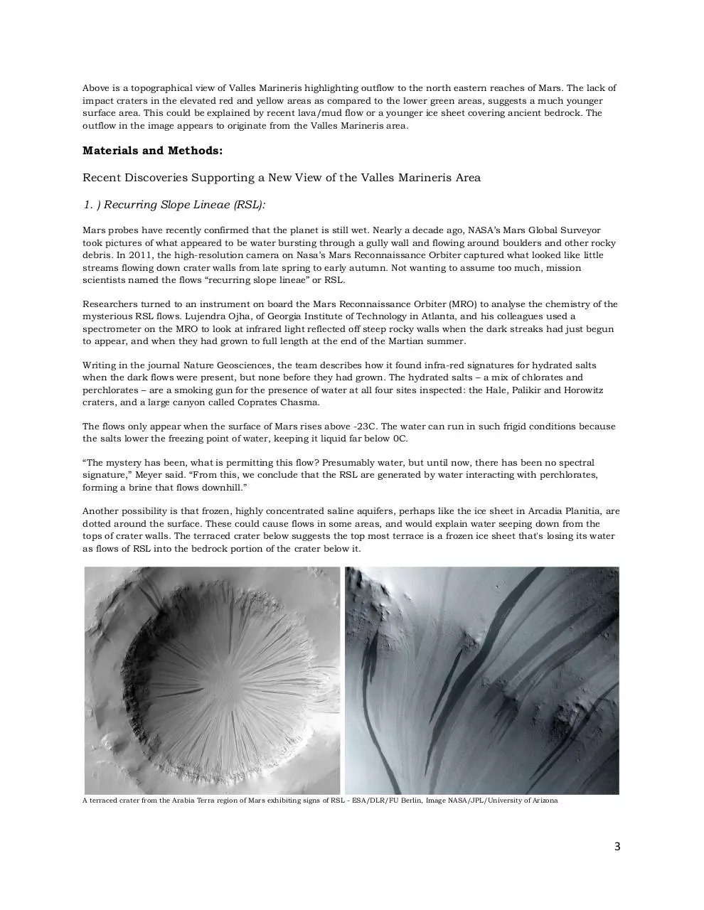
Another possibility is that frozen, highly concentrated saline aquifers, perhaps like the ice sheet in Arcadia Planitia, are
dotted around the surface. These could cause flows in some areas, and would explain water seeping down from the
tops of crater walls. The terraced crater below suggests the top most terrace is a frozen ice sheet that's losing its water
as flows of RSL into the bedrock portion of the crater below it.
A terraced crater from the Arabia Terra region of Mars exhibiting signs of RSL - ESA/DLR/FU Berlin, Image NASA/JPL/University of Arizona
3
2.) Terraced Craters:
Combining data gleaned from two powerful instruments aboard NASA’s Mars Reconnaissance Orbiter, or MRO,
recently determined why the craters in an area of Mars called Arcadia Planitia are terraced rather than bowl-shaped,
like most craters.
Terraces can form when there are layers of different materials in the planet’s subsurface, such as dirt, ice or rock.
Using MRO’s High Resolution Imaging Science Experiment, or HiRISE camera, which is operated out of JPL,
researchers created three-dimensional models of the area’s craters, which allowed them to measure the depth of their
terraces. The researchers then used MRO’s Shallow Radar, or SHARAD, instrument to beam radar pulses to Mars,
allowing them to measure the time it took for the radar signals to penetrate the surface’s buried layers and bounce
back.
Researchers combined the two data sets to measure the radar waves’ speed, a pivotal clue to the layers’ composition.
In this crater’s case, the layers turned out to be ice, and lots of it. Just beneath Mars’ dirt surface, or regolith, the
researchers found that an enormous slab of water ice, measuring 40 meters (130 feet) thick, is covering an area
equivalent to that of California and Texas combined. The researchers’ results were published in Geophysical Research
Letters, an American Geophysical Union journal.
While the presence of ice came as little surprise to some, its age, amount and location did. Although scientists have
known for some time about Mars’ icy deposits at its poles and have used them to look at its climatic history, knowledge
of icy layers at the planet’s mid latitudes is something new.
Figure 2 - ESA/DLR/FU Berlin (G. Neukim)
The top left image, taken by the High Resolution Stereo Camera (HRSC) on board ESA’s Mars Express spacecraft,
shows what is now confirmed to be a dust covered frozen sea near the Martian equator. This flat plain, part of the
Elysium Planitia, is covered with irregular blocky shapes that look just like the rafts of fragmented sea ice that lie off
the coast of Antarctica. The top right image shows confirmed flows of water ice in the Deuteronilus Mensae region of
Mars that appear to be emanating from the cliff walls. Note how dust and surface regolith covers the ice, making it
indistinguishable from the rest of the Martian landscape.
3.) Google Earth & Google Mars - Imagery of Martian Terrain and Terrestrial Analogs.
Using Google earth, I conducted research of the topographical makeup of ice sheets on the Beaufort Sea, glacial flow on
the Antarctic Peninsula, lava flows in Iceland, terrain from Mauritania and features of the Grand Canyon. Google Mars
provided data collected from three NASA Mars missions, Mars Global Surveyor, 2001 Mars Odyssey, and the Mars
Reconnaissance Orbiter.
Using the terrestrial images for comparative analysis against those from The Valles Marineris, Labyrinthus Noctus,
Echus Chasma, Echus Chaos, and Sacra Fossae areas of Mars assisted in developing new hypotheses regarding the
makeup of the Martian canyon network.
4
4.) Recently Confirmed Glaciers on Mars.
Figure 3 - ESA/DLR/FU Berlin, Image NASA/JPL/University of Arizona
The above left image from the MRO HiRISE camera shows a thick layer of dust covering a glacier, causing it to appear
as the surface of the ground, but radar measurements show that there is a glacier composed of frozen water
underneath the dust. It also shows features consistent with those from many of the Valles Marineris, Noctus
Labyrinthus, Echus Chasma, Echus Chaos and Sacra Fossae images below. The right image shows the locations of
confirmed glaciers on the Martian surface.
5.) Pedestal Craters show meters-thick ice accumulations existed in the Tharsis region of Mars.
Global climate models predict that ice would have been deposited in the Tharsis region of Mars in the past, but no
geological evidence for such deposits had ever been reported. S. C. Schon and J. W. Head at the Dept. of Geological
Sciences at Brown University discovered the presence of small pedestal craters in the tropics of Mars (the Daedalia
Planum-Tharsis region) that are superposed on an impact crater dated to ~12.5 million years ago . The characteristics,
abundance, and distribution of these small pedestal craters provided geological evidence that meters-thick ice
accumulations existed in the Tharsis region of Mars in the last few million years and may still be there this day.
Example of a Pedestal Crater in the Daedalia Planum-Tharsis region of Mars - ESA/DLR/FU Berlin, Image NASA/JPL/University of Arizona
5
Results:
Figure 4 - ESA/DLR/FU Berlin, Image NASA/JPL/University of Arizona
The image above shows an area of the Echus Chasma region on Mars that outflows to the north of Valles Marineris.
Wind has blown surface material away much as you would see snow blow across a frozen lake. There appears to be a
uniform layer of water ice that may be several hundred meters thick on the uppermost surface visible in the image.
Below that may be another layer of more ancient ice another 2-4km thick. The lowest surface of the image suggests
another frozen sheet of water. The smooth surface exhibits craters showing tails of recently excavated white material
that has been blown across the surface much as in figure 15 below. This finding would not be in alignment with a
volcanic origin but would support ice. Ripples of a frozen coastline can be seen where the lowest surface contacts the
2-4km thick cliff and these features are in alignment with what occurs on frozen Antarctic coastlines. Note the
evidence of RSL pouring from top layer of hypothetical ice, down over the cliff face, to the lowest surface, particularly in
the area where there is a break up of the material that the lowest surface is composed of. This is particulary visible in
figure 5 below. The darkest areas in the images could be attributable to a darkening caused by liquid water. The
uppermost surface in the image would be part of the hypothetical ice sheet associated with Valles Marineris as well.
Figure 5 - ESA/DLR/FU Berlin, Image NASA/JPL/University of Arizona
6
Figure 6 - ESA/DLR/FU Berlin, Image NASA/JPL/University of Arizona
Pulling back from the original view we see a wider angle where massive fissures run through the lowest surface in the
image. Closer inspection of the area reveals features such as ice fractures. This same phenomenon, associated with
water ice, is readily observable in the Arctic and Antarctic as in figure 8 further below. This kind of fracturing does not
appear to be associated with terrestrial volcanic, tectonic or lava-related processes that one is able review on the
internet today.
Figure 7 - ESA/DLR/FU Berlin, Image NASA/JPL/University of Arizona
A closer view of the Echus Chasma fissures from the above image shows processes very similar to those observable in
more terrestrial polar regions such as the Beaufort Sea in figure 8 below. Scientists currently hypothesize that the
smooth surface is attributable to lava flow, despite the fact that the area exhibits characteristics leading scientists to
also postulate that it may have once been the wettest place on Mars. It does not take a huge leap to think that the
7
water is still there, frozen under the surface regolith and thus difficult to detect by orbiters. Were the surface features
attributable to basaltic lava flow, where did the lava come from? Why does it continue to flow to the north where there
are more signs of ice and water related processes that are more in alignment with observations? In figure 4 the lowest
area does resemble some instances of basaltic lava flow in Iceland, however, the fractures are not in alignment with
any sort of lava related processes that web related research could turn up. Water is the more reasonable explanation.
Is this something we can confirm with the Mars Reconnaissance Orbiter's SHARAD, or Shallow Radar instrument as
we have on other areas of Mars?
Figure 8 - Image US Geological Survey
The above analog from a 2013 satellite image of ice fracturing in the Beaufort Sea lends credibility to the idea that the
surface in figures 6 and 7 are attributable to ice rather than lava flow. The presence of fog, which will also be discussed
later, is also clearly shown as an ice related process in the images above.
Figure 9 - ESA/DLR/FU Berlin, Image NASA/JPL/University of Arizona
Continuing north from the Echus Chasma region into Echus Chaos, we can see that the area continues to show signs
of activity consistent with water and ice. The lower portion of the image shows what appears to be the breakup and
refreezing of water ice that at some point was breaking away from the shoreline, whereas the pedestal craters in the
8
upper portion of the image show the "splat-like" ejecta pattern from impacts that we know are also in alignment with
the involvement of water and ice. There are also features on the uppermost surface in the image that are consistent
with the kind of activity one would see when water splashes across the surface of a frozen lake and then refreezes. The
current theory regarding the development of this area is that it was formed by sediments and basaltic lava flows. I
would again argue that processes attributed to the presence of water ice would be a far more reasonable explanation
for the smooth, level surfaces and erosion in the image. Having a look at where Echus Chaos lies when correlated to
the topographical map in figure 1, also shows that water and ice flow is by far the most likely process to be at work in
the area.
Figure 10 - ESA/DLR/FU Berlin, Image NASA/JPL/University of Arizona
Figure 11 - ESA/DLR/FU Berlin, Image NASA/JPL/University of Arizona
Another area north of Echus Chasma, further up the outwash channel in the Sacra Fossae region. The uppermost
surface in the image is the same as that in figures 4 and 13 which could be anywhere from several hundred meters of
ice to several km of ice in thickness. The middle layer is possibly glacial activity flowing from the colapsing remains of
the sheet supporting the topmost surface, and the lowest level, the same from figures 5, 7 & 9 above, is possibly yet
another level of ice as made apparent by the grey square inset that's zoomed in the next image. The north facing
exposures show signs of recent erosion that exposes the ice. Again, volcanic or lava-related processes are not the most
reasonable explanations for any of the processes going on in the image.
9
Download Water and Ice in the Valles Marineris Region
Water and Ice in the Valles Marineris Region.pdf (PDF, 3.93 MB)
Download PDF
Share this file on social networks
Link to this page
Permanent link
Use the permanent link to the download page to share your document on Facebook, Twitter, LinkedIn, or directly with a contact by e-Mail, Messenger, Whatsapp, Line..
Short link
Use the short link to share your document on Twitter or by text message (SMS)
HTML Code
Copy the following HTML code to share your document on a Website or Blog
QR Code to this page

This file has been shared publicly by a user of PDF Archive.
Document ID: 0000316329.