17sepREPORT (PDF)
File information
This PDF 1.4 document has been generated by / Qt 4.8.7, and has been sent on pdf-archive.com on 18/09/2016 at 05:22, from IP address 58.166.x.x.
The current document download page has been viewed 455 times.
File size: 9.14 MB (6 pages).
Privacy: public file


File preview
Woodburn17sep16
Processing Report for Sabre mapping mission with Canon s110
17 September 2016
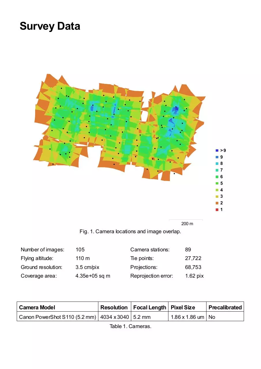
Survey Data
>9
9
8
7
6
5
4
3
2
1
200 m
Fig. 1. Camera locations and image overlap.
Number of images:
Flying altitude:
Ground resolution:
Coverage area:
Camera Model
105
110 m
3.5 cm/pix
4.35e+05 sq m
Camera stations:
Tie points:
Projections:
Reprojection error:
89
27,722
68,753
1.62 pix
Resolution Focal Length Pixel Size
Canon PowerShot S110 (5.2 mm) 4034 x 3040 5.2 mm
Table 1. Cameras.
Precalibrated
1.86 x 1.86 um No
Camera Calibration
1 pix
Fig. 2. Image residuals for Canon PowerShot S110 (5.2 mm).
Canon PowerShot S110 (5.2 mm)
105 images
Resolution
Focal Length
Pixel Size
Precalibrated
4034 x 3040
5.2 mm
1.86 x 1.86 um
No
Type:
Fx:
Fy:
K1:
K2:
K3:
K4:
Frame
2868.1
2868.1
-0.260791
0.0741983
-0.00920103
0
Skew:
Cx:
Cy:
P1:
P2:
P3:
P4:
0
2078.18
1500.06
-6.19915e-05
-0.000151167
0
0
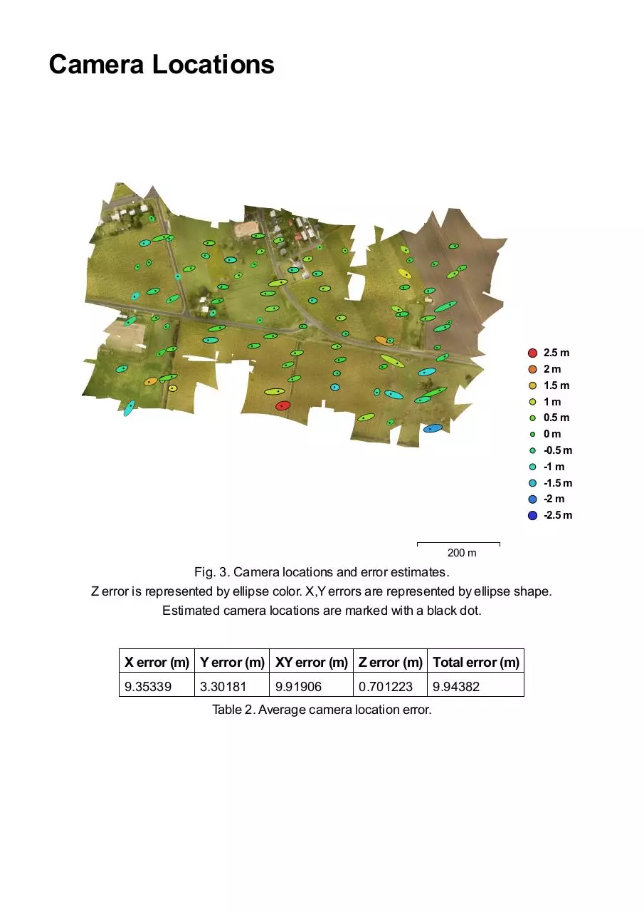
Camera Locations
2.5 m
2m
1.5 m
1m
0.5 m
0m
-0.5 m
-1 m
-1.5 m
-2 m
-2.5 m
200 m
Fig. 3. Camera locations and error estimates.
Z error is represented by ellipse color. X,Y errors are represented by ellipse shape.
Estimated camera locations are marked with a black dot.
X error (m) Y error (m) XY error (m) Z error (m) Total error (m)
9.35339
3.30181
9.91906
0.701223
Table 2. Average camera location error.
9.94382
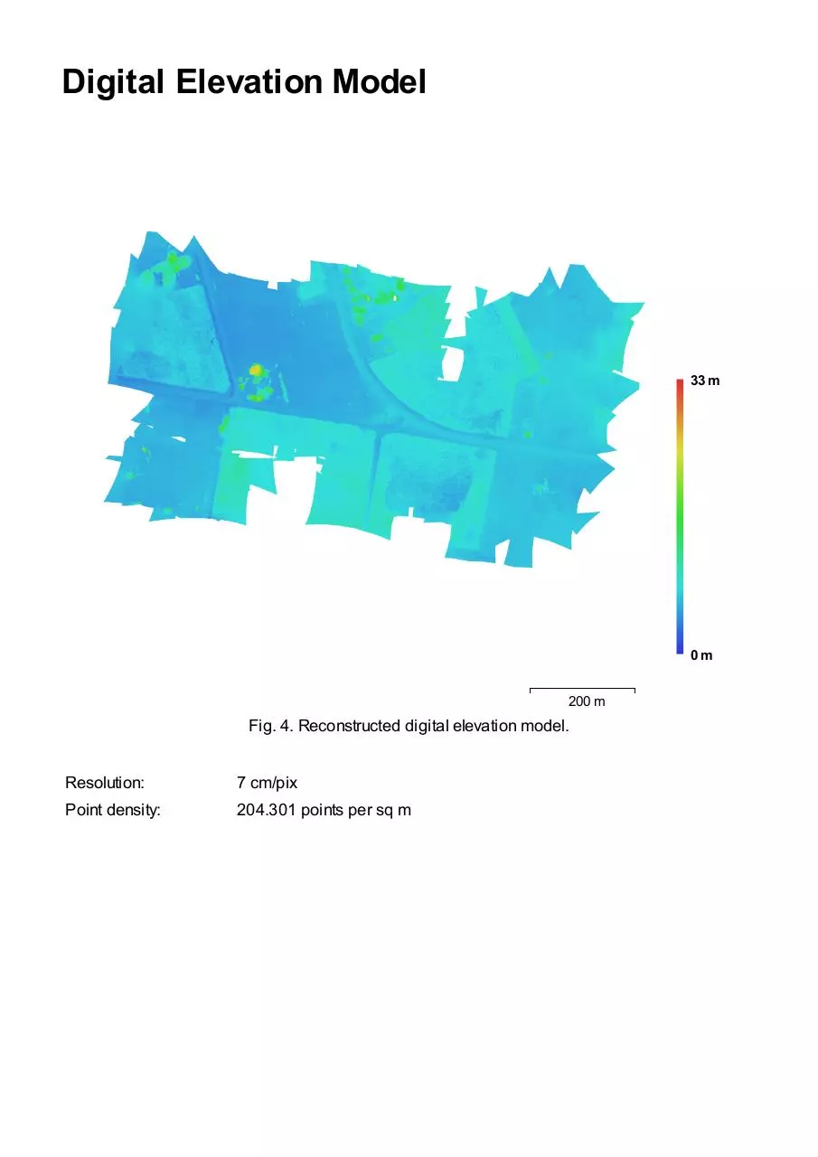
Digital Elevation Model
33 m
0m
200 m
Fig. 4. Reconstructed digital elevation model.
Resolution:
Point density:
7 cm/pix
204.301 points per sq m
Processing Parameters
General
Cameras
Aligned cameras
Coordinate system
Point Cloud
Points
RMS reprojection error
Max reprojection error
Mean key point size
Effective overlap
Alignment parameters
Accuracy
Pair preselection
Key point limit
Tie point limit
Constrain features by mask
Matching time
Alignment time
Depth Maps
Count
Reconstruction parameters
Quality
Filtering mode
Processing time
Dense Point Cloud
Points
Reconstruction parameters
Quality
Depth filtering
Processing time
Model
Faces
Vertices
Reconstruction parameters
Surface type
Source data
Interpolation
Geometry type
Face count
Processing time
DEM
Size
Coordinate system
Reconstruction parameters
Source data
Interpolation
Orthomosaic
Size
Coordinate system
Channels
Blending mode
Reconstruction parameters
Surface
Enable color correction
105
89
WGS 84 (EPSG::4326)
27,722 of 29,128
0.182174 (1.61749 pix)
0.547343 (15.4048 pix)
9.26041 pix
2.49406
Medium
Reference
40,000
1,000
No
1 minutes 59 seconds
16 seconds
89
High
Aggressive
13 minutes 14 seconds
69,772,040
High
Aggressive
5 minutes 38 seconds
29,999
15,177
Arbitrary
Sparse
Enabled
Point cloud
30,000
1 seconds
15,018 x 9,537
WGS 84 (EPSG::4326)
Dense cloud
Enabled
29,430 x 18,290
WGS 84 (EPSG::4326)
3, uint8
Mosaic
DEM
No
Download 17sepREPORT
17sepREPORT.pdf (PDF, 9.14 MB)
Download PDF
Share this file on social networks
Link to this page
Permanent link
Use the permanent link to the download page to share your document on Facebook, Twitter, LinkedIn, or directly with a contact by e-Mail, Messenger, Whatsapp, Line..
Short link
Use the short link to share your document on Twitter or by text message (SMS)
HTML Code
Copy the following HTML code to share your document on a Website or Blog
QR Code to this page

This file has been shared publicly by a user of PDF Archive.
Document ID: 0000484181.