TheTruthAboutDrones Construction (PDF)
File information
Title: Layout 1
This PDF 1.4 document has been generated by QuarkXPress(R) 9.31r1, and has been sent on pdf-archive.com on 04/11/2016 at 16:36, from IP address 97.118.x.x.
The current document download page has been viewed 1347 times.
File size: 1.34 MB (5 pages).
Privacy: public file

File preview
The Truth about Drones
in Construction and Infrastructure Inspection
They’re great tools for design, site monitoring, and asset
maintenance, but you need to learn how to integrate their data
into an ecosystem of software.
By Colin Snow, CEO and Founder of Skylogic Research
Introduction
There are significant economic and environmental benefits to
keeping buildings and other types of facilities operational and
construction sites safe. But doing so requires dull, dirty, and
dangerous work of inspection and monitoring. For example, inspecting cell and radio towers would be less risky if a drone
could be sent up first to take pictures, allowing experts to figure out what – if anything – needs to be repaired before sending a worker to begin a dangerous climb.
Drones – aka unmanned aircraft systems (UAS) -- are poised to
perform many of these types of functions, because they can
take high-resolution images, capture video, and do laser scanning remotely by an operator on the ground. They can also deliver some new capabilities for architectural and construction
The simple truth is small drones -- in
particular multirotors -- can fly lower
and closer than traditional aircraft and
capture more useful detailed information.
firms. Multirotor drones in particular are highly adept at this,
since they can get into tight spaces and provide low-altitude
data capture that traditional aircraft cannot. With the advent of
smaller/lighter survey-grade LiDAR, the combo provides a stable and portable platform for precision scanning of large structures like bridges.
As we have written here, there are some pretty fantastic and
unrealistic forecasts for how fast the commercial drone industry will grow overall. We believe demand and growth for drones
will be selective by use case and industry vertical, and we believe inspection and monitoring is one sector that will do better
than others. Goldman Sachs estimates that of the total global
spending over the next five years on drones in the commercial
market, about $11.2 billion will be generated by the construction industry, with $1.3 billion in the U.S. alone. This is a reasonable TAM forecast and shows the potential scale of this
sector for drones.
In this paper, we’ll show how drones have been used successfully in construction and infrastructure asset management as
aerial image and data capture devices thus far, review competitive and traditional approaches using incumbent technology,
discuss the opportunities and challenges posed by the technology itself, outline the lessons learned, and discuss what’s next
for drones in this industry.
Use cases
Construction giant Bechtel was one of the first to use drone
technology in construction. In 2013 they teamed with Skycatch
to prove the technology’s viability at one of the largest liquefied
natural gas projects in Australia. Bechtel used the technology
2 © Skylogic Research, LLC
to do things like collect real-time environmental data (e.g., air
quality, temperature, etc.), survey difficult and inaccessible terrain, and track real-time construction progress.
Since then, hundreds of firms across the globe have put in
place proof-of-concept projects for drones – not just for construction but also for civil infrastructure and asset management purposes. The list of all projects is too long for this
paper, but we’ll explore the major project types according to a
commonly used building lifecycle framework of design, construction, operation, and demolition.
1. Design
Drone imagery and data have been found to be useful tools in
design and preconstruction workflows for commercial construction and architectural firms like The Beck Group, DPR Construction, and SANDIS. One prominent use is taking an aerial shot
of what potential tenants and investors see when they look out
from their East-facing 10th floor office. These visuals include:
• Future building face/reface views for development
• Building models in neighborhood context
• 180- or 360-degree visualizations from each floor
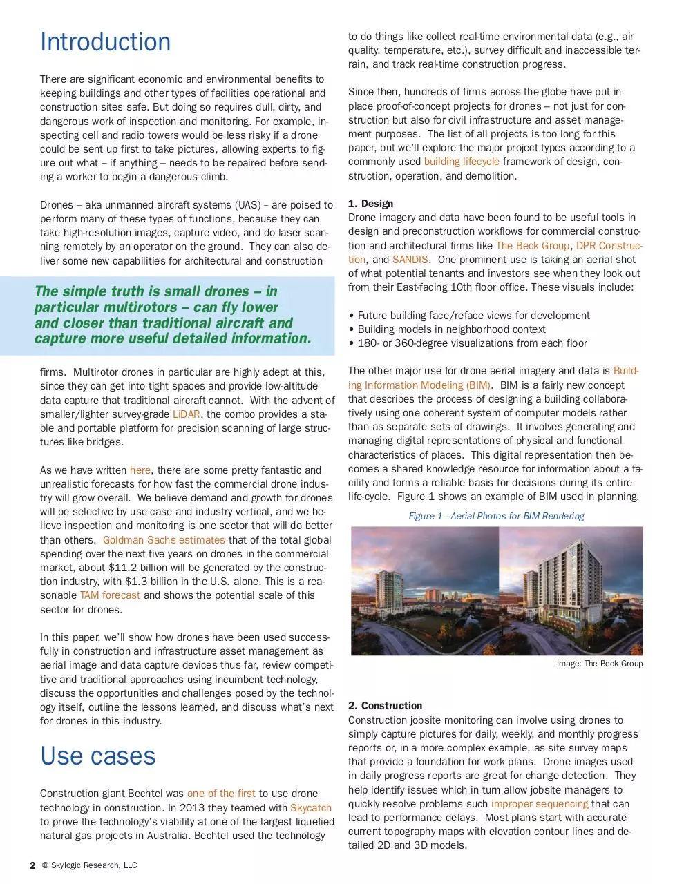
The other major use for drone aerial imagery and data is Building Information Modeling (BIM). BIM is a fairly new concept
that describes the process of designing a building collaboratively using one coherent system of computer models rather
than as separate sets of drawings. It involves generating and
managing digital representations of physical and functional
characteristics of places. This digital representation then becomes a shared knowledge resource for information about a facility and forms a reliable basis for decisions during its entire
life-cycle. Figure 1 shows an example of BIM used in planning.
Figure 1 - Aerial Photos for BIM Rendering
Image: The Beck Group
2. Construction
Construction jobsite monitoring can involve using drones to
simply capture pictures for daily, weekly, and monthly progress
reports or, in a more complex example, as site survey maps
that provide a foundation for work plans. Drone images used
in daily progress reports are great for change detection. They
help identify issues which in turn allow jobsite managers to
quickly resolve problems such improper sequencing that can
lead to performance delays. Most plans start with accurate
current topography maps with elevation contour lines and detailed 2D and 3D models.
Work plans can include:
• Georeferenced cut and fill and
earthwork hauling specifications
• Asset management including materials, equipment, temporary
roads, and structures
• Stockpile volumes for labor and
time estimates to move/remove
• Egress and on-site logistics for
vehicles and heavy machinery
• Quality control (CAD plan vs. actual)
• Regulatory compliance and
progress reporting
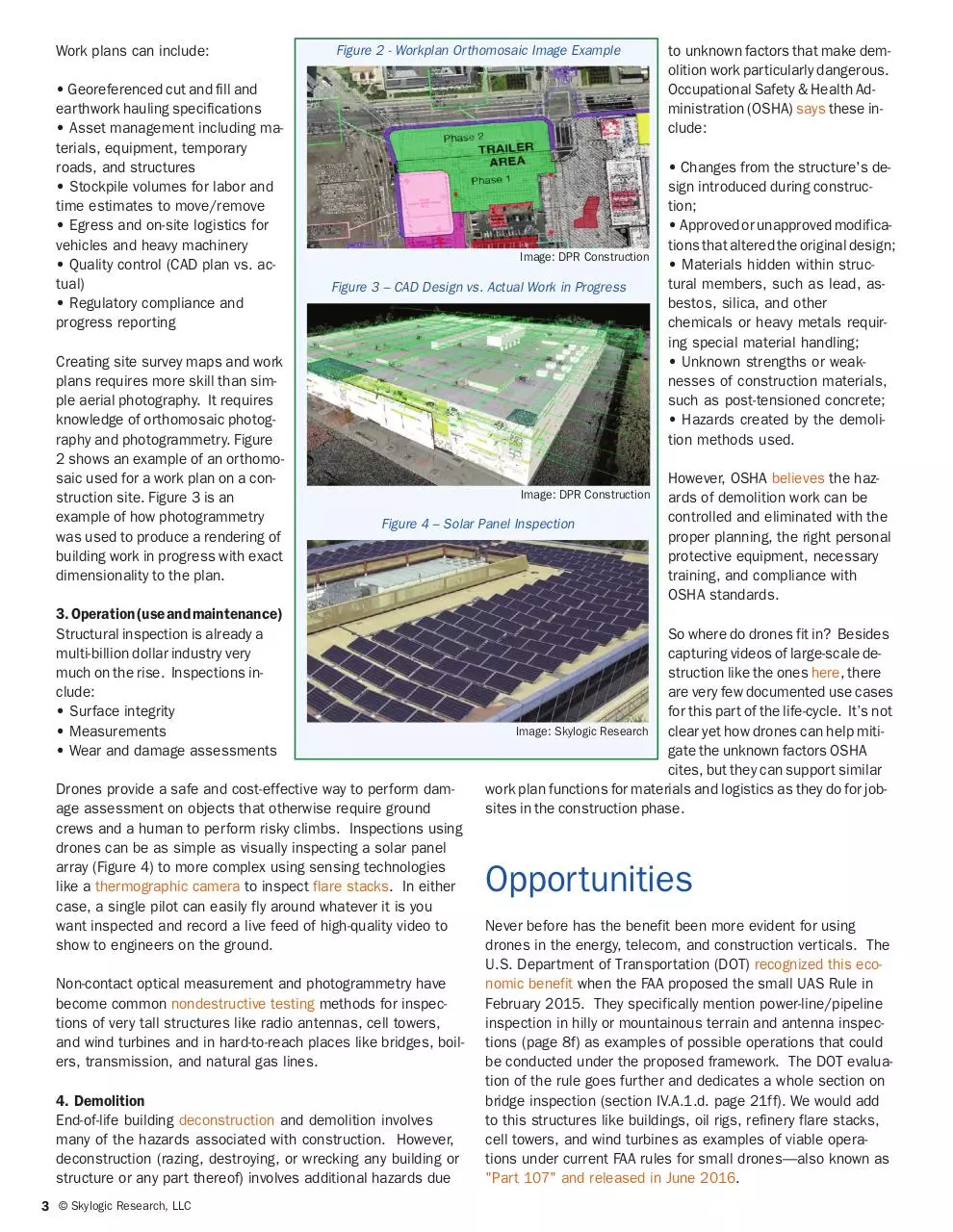
Creating site survey maps and work
plans requires more skill than simple aerial photography. It requires
knowledge of orthomosaic photography and photogrammetry. Figure
2 shows an example of an orthomosaic used for a work plan on a construction site. Figure 3 is an
example of how photogrammetry
was used to produce a rendering of
building work in progress with exact
dimensionality to the plan.
Figure 2 - Workplan Orthomosaic Image Example
Image: DPR Construction
Figure 3 – CAD Design vs. Actual Work in Progress
Image: DPR Construction
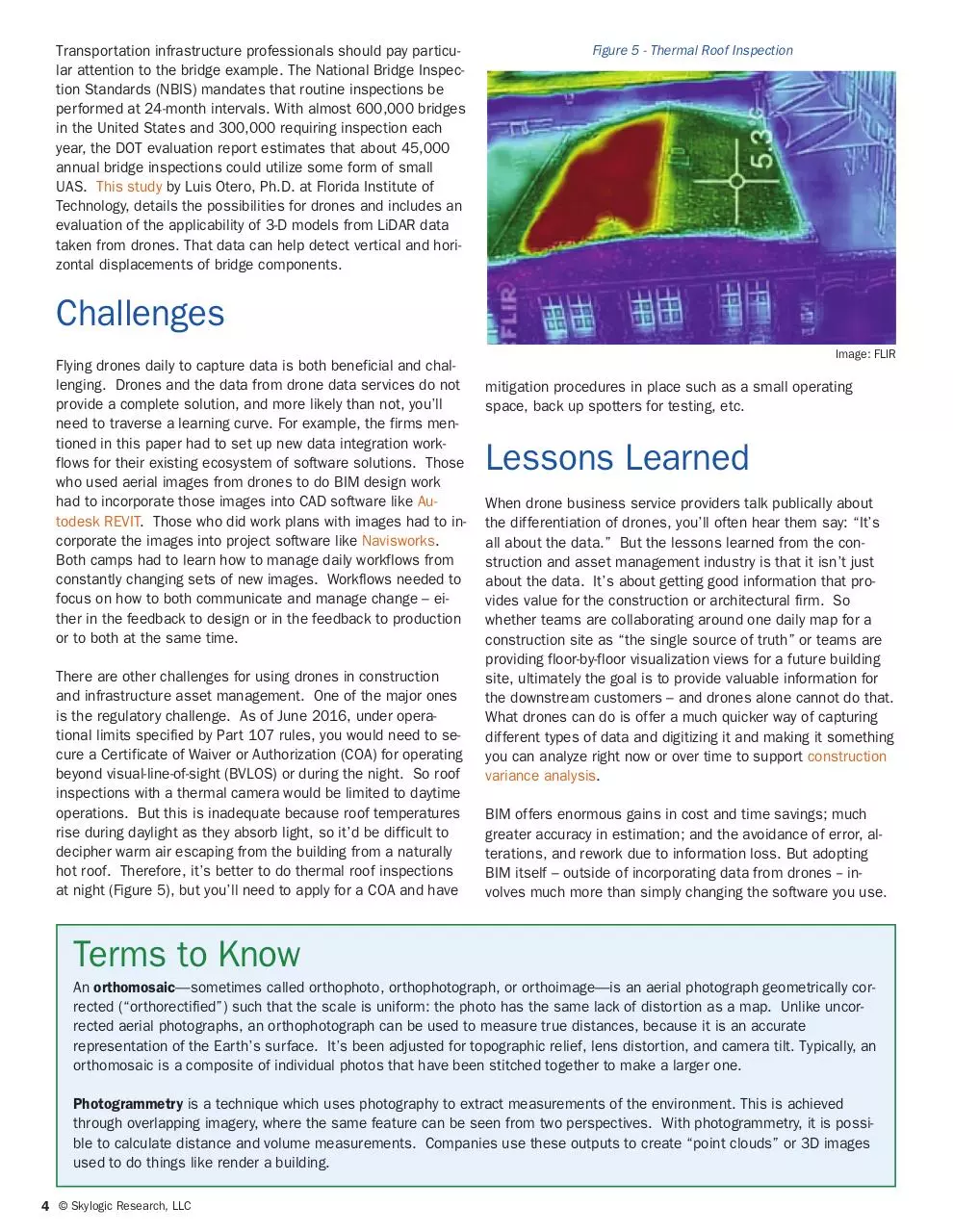
Figure 4 – Solar Panel Inspection
3.Operation(useandmaintenance)
Structural inspection is already a
multi-billion dollar industry very
much on the rise. Inspections include:
• Surface integrity
• Measurements
• Wear and damage assessments
Drones provide a safe and cost-effective way to perform damage assessment on objects that otherwise require ground
crews and a human to perform risky climbs. Inspections using
drones can be as simple as visually inspecting a solar panel
array (Figure 4) to more complex using sensing technologies
like a thermographic camera to inspect flare stacks. In either
case, a single pilot can easily fly around whatever it is you
want inspected and record a live feed of high-quality video to
show to engineers on the ground.
Non-contact optical measurement and photogrammetry have
become common nondestructive testing methods for inspections of very tall structures like radio antennas, cell towers,
and wind turbines and in hard-to-reach places like bridges, boilers, transmission, and natural gas lines.
4. Demolition
End-of-life building deconstruction and demolition involves
many of the hazards associated with construction. However,
deconstruction (razing, destroying, or wrecking any building or
structure or any part thereof) involves additional hazards due
3 © Skylogic Research, LLC
to unknown factors that make demolition work particularly dangerous.
Occupational Safety & Health Administration (OSHA) says these include:
• Changes from the structure's design introduced during construction;
• Approved or unapproved modifications that altered the original design;
• Materials hidden within structural members, such as lead, asbestos, silica, and other
chemicals or heavy metals requiring special material handling;
• Unknown strengths or weaknesses of construction materials,
such as post-tensioned concrete;
• Hazards created by the demolition methods used.
However, OSHA believes the hazards of demolition work can be
controlled and eliminated with the
proper planning, the right personal
protective equipment, necessary
training, and compliance with
OSHA standards.
So where do drones fit in? Besides
capturing videos of large-scale destruction like the ones here, there
are very few documented use cases
for this part of the life-cycle. It’s not
Image: Skylogic Research
clear yet how drones can help mitigate the unknown factors OSHA
cites, but they can support similar
work plan functions for materials and logistics as they do for jobsites in the construction phase.
Opportunities
Never before has the benefit been more evident for using
drones in the energy, telecom, and construction verticals. The
U.S. Department of Transportation (DOT) recognized this economic benefit when the FAA proposed the small UAS Rule in
February 2015. They specifically mention power-line/pipeline
inspection in hilly or mountainous terrain and antenna inspections (page 8f) as examples of possible operations that could
be conducted under the proposed framework. The DOT evaluation of the rule goes further and dedicates a whole section on
bridge inspection (section IV.A.1.d. page 21ff). We would add
to this structures like buildings, oil rigs, refinery flare stacks,
cell towers, and wind turbines as examples of viable operations under current FAA rules for small drones—also known as
"Part 107" and released in June 2016.
Transportation infrastructure professionals should pay particular attention to the bridge example. The National Bridge Inspection Standards (NBIS) mandates that routine inspections be
performed at 24-month intervals. With almost 600,000 bridges
in the United States and 300,000 requiring inspection each
year, the DOT evaluation report estimates that about 45,000
annual bridge inspections could utilize some form of small
UAS. This study by Luis Otero, Ph.D. at Florida Institute of
Technology, details the possibilities for drones and includes an
evaluation of the applicability of 3-D models from LiDAR data
taken from drones. That data can help detect vertical and horizontal displacements of bridge components.
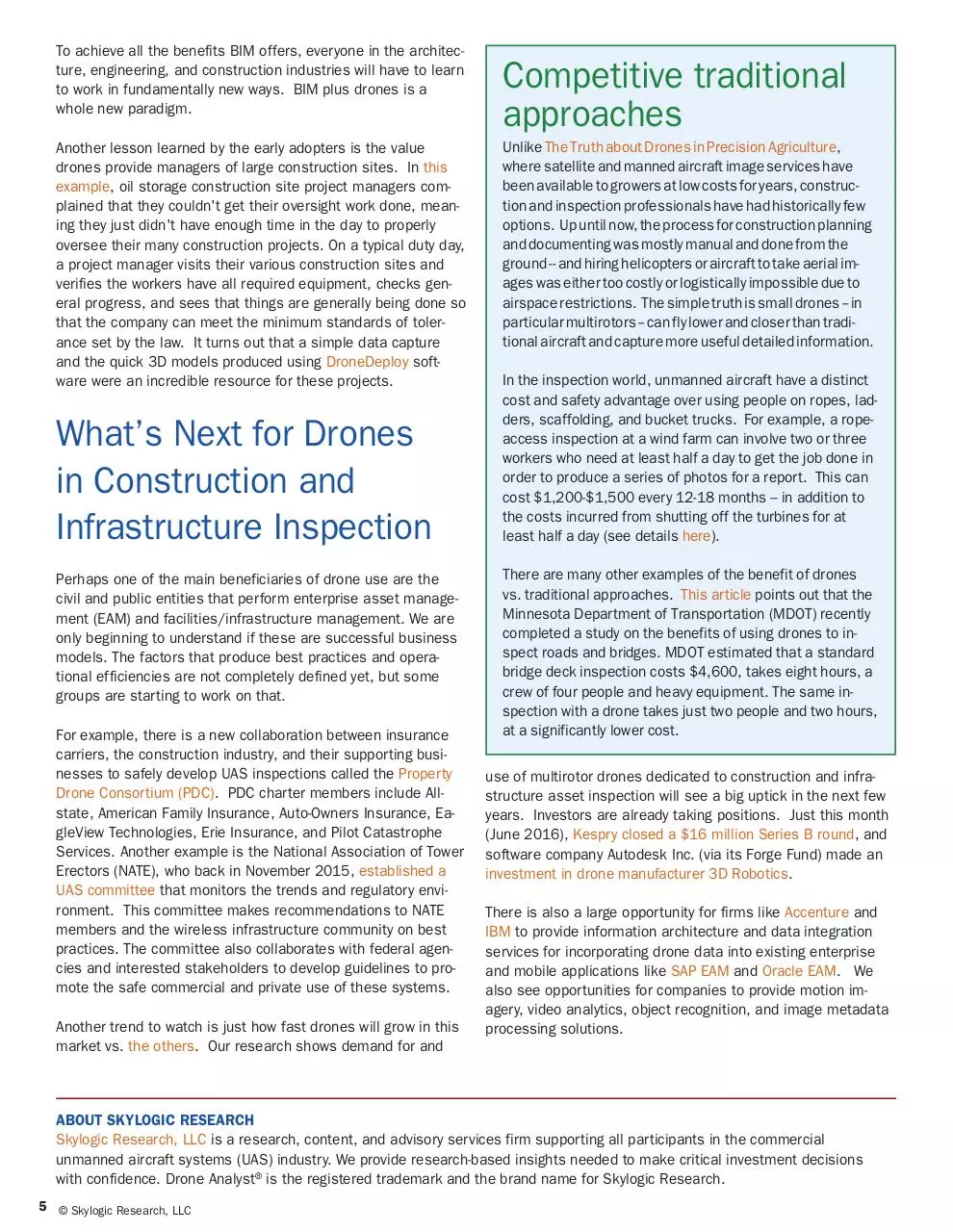
Figure 5 - Thermal Roof Inspection
Challenges
Image: FLIR
Flying drones daily to capture data is both beneficial and challenging. Drones and the data from drone data services do not
provide a complete solution, and more likely than not, you’ll
need to traverse a learning curve. For example, the firms mentioned in this paper had to set up new data integration workflows for their existing ecosystem of software solutions. Those
who used aerial images from drones to do BIM design work
had to incorporate those images into CAD software like Autodesk REVIT. Those who did work plans with images had to incorporate the images into project software like Navisworks.
Both camps had to learn how to manage daily workflows from
constantly changing sets of new images. Workflows needed to
focus on how to both communicate and manage change – either in the feedback to design or in the feedback to production
or to both at the same time.
There are other challenges for using drones in construction
and infrastructure asset management. One of the major ones
is the regulatory challenge. As of June 2016, under operational limits specified by Part 107 rules, you would need to secure a Certificate of Waiver or Authorization (COA) for operating
beyond visual-line-of-sight (BVLOS) or during the night. So roof
inspections with a thermal camera would be limited to daytime
operations. But this is inadequate because roof temperatures
rise during daylight as they absorb light, so it’d be difficult to
decipher warm air escaping from the building from a naturally
hot roof. Therefore, it’s better to do thermal roof inspections
at night (Figure 5), but you’ll need to apply for a COA and have
mitigation procedures in place such as a small operating
space, back up spotters for testing, etc.
Lessons Learned
When drone business service providers talk publically about
the differentiation of drones, you’ll often hear them say: “It’s
all about the data.” But the lessons learned from the construction and asset management industry is that it isn’t just
about the data. It’s about getting good information that provides value for the construction or architectural firm. So
whether teams are collaborating around one daily map for a
construction site as “the single source of truth” or teams are
providing floor-by-floor visualization views for a future building
site, ultimately the goal is to provide valuable information for
the downstream customers – and drones alone cannot do that.
What drones can do is offer a much quicker way of capturing
different types of data and digitizing it and making it something
you can analyze right now or over time to support construction
variance analysis.
BIM offers enormous gains in cost and time savings; much
greater accuracy in estimation; and the avoidance of error, alterations, and rework due to information loss. But adopting
BIM itself – outside of incorporating data from drones -- involves much more than simply changing the software you use.
Terms to Know
An orthomosaic—sometimes called orthophoto, orthophotograph, or orthoimage—is an aerial photograph geometrically corrected (“orthorectified”) such that the scale is uniform: the photo has the same lack of distortion as a map. Unlike uncorrected aerial photographs, an orthophotograph can be used to measure true distances, because it is an accurate
representation of the Earth’s surface. It’s been adjusted for topographic relief, lens distortion, and camera tilt. Typically, an
orthomosaic is a composite of individual photos that have been stitched together to make a larger one.
Photogrammetry is a technique which uses photography to extract measurements of the environment. This is achieved
through overlapping imagery, where the same feature can be seen from two perspectives. With photogrammetry, it is possible to calculate distance and volume measurements. Companies use these outputs to create “point clouds” or 3D images
used to do things like render a building.
4 © Skylogic Research, LLC
To achieve all the benefits BIM offers, everyone in the architecture, engineering, and construction industries will have to learn
to work in fundamentally new ways. BIM plus drones is a
whole new paradigm.
Another lesson learned by the early adopters is the value
drones provide managers of large construction sites. In this
example, oil storage construction site project managers complained that they couldn't get their oversight work done, meaning they just didn't have enough time in the day to properly
oversee their many construction projects. On a typical duty day,
a project manager visits their various construction sites and
verifies the workers have all required equipment, checks general progress, and sees that things are generally being done so
that the company can meet the minimum standards of tolerance set by the law. It turns out that a simple data capture
and the quick 3D models produced using DroneDeploy software were an incredible resource for these projects.
What’s Next for Drones
in Construction and
Infrastructure Inspection
Perhaps one of the main beneficiaries of drone use are the
civil and public entities that perform enterprise asset management (EAM) and facilities/infrastructure management. We are
only beginning to understand if these are successful business
models. The factors that produce best practices and operational efficiencies are not completely defined yet, but some
groups are starting to work on that.
For example, there is a new collaboration between insurance
carriers, the construction industry, and their supporting businesses to safely develop UAS inspections called the Property
Drone Consortium (PDC). PDC charter members include Allstate, American Family Insurance, Auto-Owners Insurance, EagleView Technologies, Erie Insurance, and Pilot Catastrophe
Services. Another example is the National Association of Tower
Erectors (NATE), who back in November 2015, established a
UAS committee that monitors the trends and regulatory environment. This committee makes recommendations to NATE
members and the wireless infrastructure community on best
practices. The committee also collaborates with federal agencies and interested stakeholders to develop guidelines to promote the safe commercial and private use of these systems.
Another trend to watch is just how fast drones will grow in this
market vs. the others. Our research shows demand for and
Competitive traditional
approaches
Unlike The Truth about Drones in Precision Agriculture,
where satellite and manned aircraft image services have
been available to growers at low costs for years, construction and inspection professionals have had historically few
options. Up until now, the process for construction planning
and documenting was mostly manual and done from the
ground -- and hiring helicopters or aircraft to take aerial images was either too costly or logistically impossible due to
airspace restrictions. The simple truth is small drones -- in
particular multirotors -- can fly lower and closer than traditional aircraft and capture more useful detailed information.
In the inspection world, unmanned aircraft have a distinct
cost and safety advantage over using people on ropes, ladders, scaffolding, and bucket trucks. For example, a ropeaccess inspection at a wind farm can involve two or three
workers who need at least half a day to get the job done in
order to produce a series of photos for a report. This can
cost $1,200-$1,500 every 12-18 months – in addition to
the costs incurred from shutting off the turbines for at
least half a day (see details here).
There are many other examples of the benefit of drones
vs. traditional approaches. This article points out that the
Minnesota Department of Transportation (MDOT) recently
completed a study on the benefits of using drones to inspect roads and bridges. MDOT estimated that a standard
bridge deck inspection costs $4,600, takes eight hours, a
crew of four people and heavy equipment. The same inspection with a drone takes just two people and two hours,
at a significantly lower cost.
use of multirotor drones dedicated to construction and infrastructure asset inspection will see a big uptick in the next few
years. Investors are already taking positions. Just this month
(June 2016), Kespry closed a $16 million Series B round, and
software company Autodesk Inc. (via its Forge Fund) made an
investment in drone manufacturer 3D Robotics.
There is also a large opportunity for firms like Accenture and
IBM to provide information architecture and data integration
services for incorporating drone data into existing enterprise
and mobile applications like SAP EAM and Oracle EAM. We
also see opportunities for companies to provide motion imagery, video analytics, object recognition, and image metadata
processing solutions.
ABOUT SKYLOGIC RESEARCH
Skylogic Research, LLC is a research, content, and advisory services firm supporting all participants in the commercial
unmanned aircraft systems (UAS) industry. We provide research-based insights needed to make critical investment decisions
with confidence. Drone Analyst® is the registered trademark and the brand name for Skylogic Research.
5 © Skylogic Research, LLC
Download TheTruthAboutDrones Construction
TheTruthAboutDrones_Construction.pdf (PDF, 1.34 MB)
Download PDF
Share this file on social networks
Link to this page
Permanent link
Use the permanent link to the download page to share your document on Facebook, Twitter, LinkedIn, or directly with a contact by e-Mail, Messenger, Whatsapp, Line..
Short link
Use the short link to share your document on Twitter or by text message (SMS)
HTML Code
Copy the following HTML code to share your document on a Website or Blog
QR Code to this page

This file has been shared publicly by a user of PDF Archive.
Document ID: 0000503637.