Pilling Pilot Navigation Flight Planner Canada Instructions (PDF)
File information
This PDF 1.4 document has been generated by Draw / OpenOffice.org 3.0, and has been sent on pdf-archive.com on 29/11/2017 at 02:14, from IP address 174.138.x.x.
The current document download page has been viewed 204 times.
File size: 150.58 KB (3 pages).
Privacy: public file
File preview
Freq: 122.7 DeptPt-DIST: 7 TIME: 4 CH: 354
712
Climb / Taxi, T/O & Land Time
Port Albert
2300 5 / 10 min ALT: 5500 IAS: 99
Wnd
EN ROUTE
Enter new GS
Agl
20 120 10 in Rvsd GS-box
WIND WIND OAT -7 DIST / TIME=Rvsd GS
LEG#1: Goderich
Departure Point
MP /
RPM:
YGD
TT/MT
DIR
SPD
026
285
15
WCA
ENG
ON:
Distance, Time and Heading to Your Departure Point
Elev:
TAS
102
TH
MH
018 028
A/C
+10 Dev +2
ENG
17:48 Z OFF:
18:35 Z DEPT
TIME: 18:00 Z
Spd
Cor
Cps
Var
DIST
GS
58
ETA:
TIME
104
120
18:34 Z
Airport /
Radio
122.2
Waypoint Wiarton YVV
Freq
ATIS,PRO
NOTAMs Rwy 05/23 Closed – Air Show
Runways /
Rwy 05/23 & 11/27, NDBs/w
Nav Aids
MET/TAF Wind Dir Wind Spd Visibility Precip
Cloud
CH
34 030
29 035
ATA: 18:29 Z
Calc
Rvsd
Wiart 265 10
Aprt
Elev
Grnd
Time
729
1 HR
326, VOR 117.7
Temp/Dew
Alt Set
15 None Few 6500 4/-3 30.34
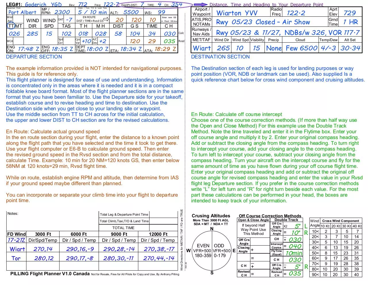
DEPARTURE SECTION
DESTINATION SECTION
The example information provided is NOT intended for navigational purposes.
This guide is for reference only.
This flight planner is designed for ease of use and understanding. Information
is concentrated only in the areas where it is needed and it is in a compact
foldable knee board format. Most of the flight planner sections are in the same
format that you have been familiar to. Use the Departure side for your takeoff,
establish course and to revise heading and time to destination. Use the
Destination side when you get close to your landing site or waypoint.
Use the middle section from TT to CH across for the initial calculation,
the upper and lower DIST to CH section are for the revised calculations.
The Destination section of each leg is used for landing purposes or way
point position (VOR, NDB or landmark can be used). Also supplied Is a
quick reference chart below for cross wind component and cruising altitudes.
En Route: Calculate off course intercept
Choose one of the course correction methods. (If more than half way use
the Open and Close Method) For this example use the Double Track
Method. Note the time traveled and enter it in the Flytime box. Enter your
off course angle and multiply it by 2. Enter your original compass heading.
Add or subtract the closing angle from the compass heading. To turn right
to intercept your course, add your closing angle to the compass heading.
To turn left to intercept your course, subtract your closing angle from the
compass heading. Turn your aircraft on the intercept course and fly for the
same amount of time as you have flown during your off course flight time.
Enter your original compass heading and add or subtract the original off
course angle for revised compass heading and enter the value in your Rvsd
flight leg Departure section. If you prefer in the course correction methods
write “L” for left turn and “R” for right turn beside each value. For the most
part these calculations can be performed in your head, the boxes are
intended to keep track of your information.
En Route: Calculate actual ground speed
In the en route section during your flight, enter the distance to a known point
along the flight path that you have selected and the time it took to get there.
Use your flight computer or E6-B to calculate ground speed. Then enter
the revised ground speed in the Rvsd section and from the total distance,
calculate Time. Example: 10 min for 20 NM=120 knots GS, then enter below
58NM at 120 knots=29 min, Rvsd flight time.
While on route, establish engine RPM and altitude, then determine from IAS
if your ground speed maybe different than planned.
Notes:
Total Leg & Departure Point Time
Total Climb,Taxi,T/O & Land Time
TOTAL TIME
FD Wind
17-21Z
3000 Ft
Dir/Spd/Temp
6000 Ft
Dir / Spd / Temp
9000 Ft
Dir / Spd / Temp
12000 Ft
Dir / Spd / Temp
Wiart
270,14
290,16,-9
290,28,-14
270,38,-17
Tor
280,12
290,17,-8
280,30,-11
270,44,-14
PILLING Flight Planner V1.0 Canada
Not for Resale, Free for All Pilots for Copy and Use, By Anthony Pilling
Wind Directions for METAR / TAF / FD are TRUE
7461-80
You can incorporate or separate your climb time into your flight to departure
point time.
Crusing Altitudes
More Than 3000 Ft AGL
SDA = MT / NDA = TT
N
EVEN ODD
W VFR+500 VFR+500 E
180-359 0-179
S
Off Course Correction Methods
Open & Close Angle
If beyond Half
Way Point Use
This Method
Off Crs
Angle
Closing
Angle
+
=
_
CH
+
Revised
CH =
Double Track
5ް L
=
_ 10ް R
CH + 030
Intercept
Course = 040
FlyTime
(Equal)
10min
CH
030
_
Off Crs
5ް R
Angle +
Revised
= 035
CH
Off Crs
Angle X2
Closing
Angle
Wind Cross Wind Component
Angle 10 Kt 20 Kt 30 Kt 40 Kt
10< 2
20< 3
30< 5
40< 6
50< 8
60< 9
70< 9
80< 10
90< 10
3
7
10
13
15
17
19
20
20
5
10
15
19
23
26
28
30
30
7
14
20
26
31
35
38
39
40
Freq: 122.7 DeptPt-DIST: 7 TIME: 4 CH: 354
712
Climb / Taxi, T/O & Land Time
Port Albert
2300 5 / 10 min ALT: 5500 IAS: 99
Wnd
EN ROUTE
Enter new GS
Agl
20 120 10 in Rvsd GS-box
WIND WIND OAT -7 DIST / TIME=Rvsd GS
LEG#1: Goderich
Departure Point
MP /
RPM:
YGD
TT/MT
DIR
SPD
026
285
15
Elev:
TAS
MH
DIST
GS
TIME
CH
018 028 58 104 34 030 Calc
A/C
WCA
+10 Dev +2
120 29 035 Rvsd
ENG
ENG
DEPT
ON: 17:48 Z OFF: 18:35 Z TIME: 18:00 Z ETA: 18:34 Z ATA: 18:29 Z
LEG#2: Wiarton YVV
Elev: 729
Freq: 122.2 DeptPt-DIST: 12 TIME: 6
CH: 140
Departure Point
Climb / Taxi, T/O & Land Time
MP /
Owen Sound RPM: 2300
3 / 10 min ALT: 5500 IAS: 99
Wnd
EN ROUTE
Enter new GS
Agl 148 WIND WIND OAT
DIST / TIME=Rvsd GS
in Rvsd GS-box
TT/MT
DIR
SPD
102
TH
Spd
Cor
TAS
Cps
Var
TH
MH
DIST
GS
TIME
CH
147 295 15 102
151
67 115
34 152 Calc
Spd
Cps
A/C
WCA
Rvsd
+4 mag
Cor +13 Var
Dev +1
ENG
ENG
DEPT
ON: 19:45 Z OFF: 20:40 Z TIME:20:00 Z ETA: 20:34 Z ATA: 20:34 Z
Notes:
Total Leg & Departure Point Time
Add 1 hr for ground time -
Total Climb,Taxi,T/O & Land Time
TOTAL TIME
1:18
1:28
2:46
FD Wind
3000 Ft
Dir/Spd/Temp
6000 Ft
Dir / Spd / Temp
9000 Ft
Dir / Spd / Temp
12000 Ft
Dir / Spd / Temp
Wiart
270,14
290,16,-9
290,28,-14
270,38,-17
Tor
280,12
290,17,-8
280,30,-11
270,44,-14
17-21Z
PILLING Flight Planner V1.0 Canada
Not for Resale, Free for All Pilots for Copy and Use, By Anthony Pilling
Wind Directions for METAR / TAF / FD are TRUE
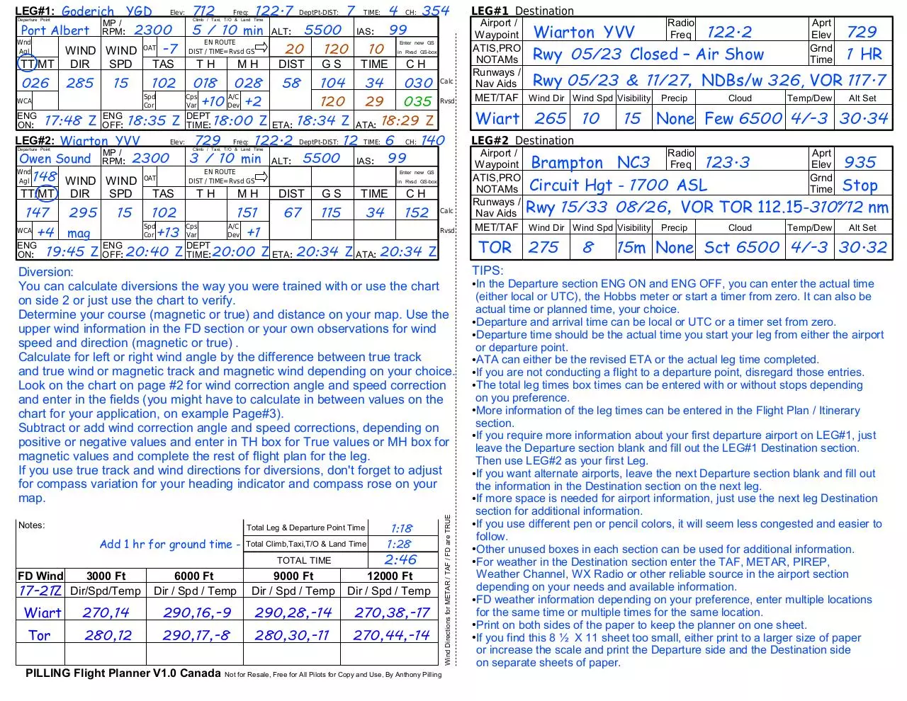
Diversion:
You can calculate diversions the way you were trained with or use the chart
on side 2 or just use the chart to verify.
Determine your course (magnetic or true) and distance on your map. Use the
upper wind information in the FD section or your own observations for wind
speed and direction (magnetic or true) .
Calculate for left or right wind angle by the difference between true track
and true wind or magnetic track and magnetic wind depending on your choice.
Look on the chart on page #2 for wind correction angle and speed correction
and enter in the fields (you might have to calculate in between values on the
chart for your application, on example Page#3).
Subtract or add wind correction angle and speed corrections, depending on
positive or negative values and enter in TH box for True values or MH box for
magnetic values and complete the rest of flight plan for the leg.
If you use true track and wind directions for diversions, don't forget to adjust
for compass variation for your heading indicator and compass rose on your
map.
LEG#1 Destination
Airport /
Radio
122.2
Waypoint Wiarton YVV
Freq
ATIS,PRO
NOTAMs Rwy 05/23 Closed – Air Show
Runways /
Rwy 05/23 & 11/27, NDBs/w
Nav Aids
MET/TAF Wind Dir Wind Spd Visibility Precip
Cloud
Wiart 265 10
LEG#2 Destination
TIPS:
8
729
1 HR
326, VOR 117.7
Temp/Dew
Alt Set
15 None Few 6500 4/-3 30.34
Airport /
Radio
Waypoint Brampton NC3
Freq 123.3
ATIS,PRO
NOTAMs Circuit Hgt - 1700 ASL
Runways /
Nav Aids Rwy 15/33 08/26, VOR TOR
MET/TAF Wind Dir Wind Spd Visibility Precip
Cloud
TOR 275
Aprt
Elev
Grnd
Time
Aprt
Elev
Grnd
Time
935
Stop
112.15-310ް/12 nm
Temp/Dew
Alt Set
15m None Sct 6500 4/-3 30.32
In the Departure section ENG ON and ENG OFF, you can enter the actual time
(either local or UTC), the Hobbs meter or start a timer from zero. It can also be
actual time or planned time, your choice.
●Departure and arrival time can be local or UTC or a timer set from zero.
●Departure time should be the actual time you start your leg from either the airport
or departure point.
●ATA can either be the revised ETA or the actual leg time completed.
●If you are not conducting a flight to a departure point, disregard those entries.
●The total leg times box times can be entered with or without stops depending
on you preference.
●More information of the leg times can be entered in the Flight Plan / Itinerary
section.
●If you require more information about your first departure airport on LEG#1, just
leave the Departure section blank and fill out the LEG#1 Destination section.
Then use LEG#2 as your first Leg.
●If you want alternate airports, leave the next Departure section blank and fill out
the information in the Destination section on the next leg.
●If more space is needed for airport information, just use the next leg Destination
section for additional information.
●If you use different pen or pencil colors, it will seem less congested and easier to
follow.
●Other unused boxes in each section can be used for additional information.
●For weather in the Destination section enter the TAF, METAR, PIREP,
Weather Channel, WX Radio or other reliable source in the airport section
depending on your needs and available information.
●FD weather information depending on your preference, enter multiple locations
for the same time or multiple times for the same location.
●Print on both sides of the paper to keep the planner on one sheet.
●If you find this 8 ½ X 11 sheet too small, either print to a larger size of paper
or increase the scale and print the Departure side and the Destination side
on separate sheets of paper.
●
0
-10
0
-20
0
-30
10<
1
-10
2
-20
3
-30
20<
2
-9
3
-19
5
-29
30<
2
-9
5
-18
7
-27
40<
3
-8
6
-16
10
-25
50<
4
-7
8
-14
12
-22
60<
4
-5
9
-11
13
-18
70<
5
-4
9
-8
14
-14
80<
5
-2
10
-5
15
-9
90<
5
0
10
-2
15
-4
100<
5
+1
10
+2
15
+1
110<
5
+3
9
+5
14
+7
120<
4
+5
9
+9
13
+12
130<
4
+6
8
+12
12
+17
140<
3
+7
6
+15
10
+21
150<
2
+9
5
+17
7
+25
160<
2
+9
3
+19
5
+28
170<
1
+10
2
+20
3
+29
180<
0
+10
0
+20
0
+30
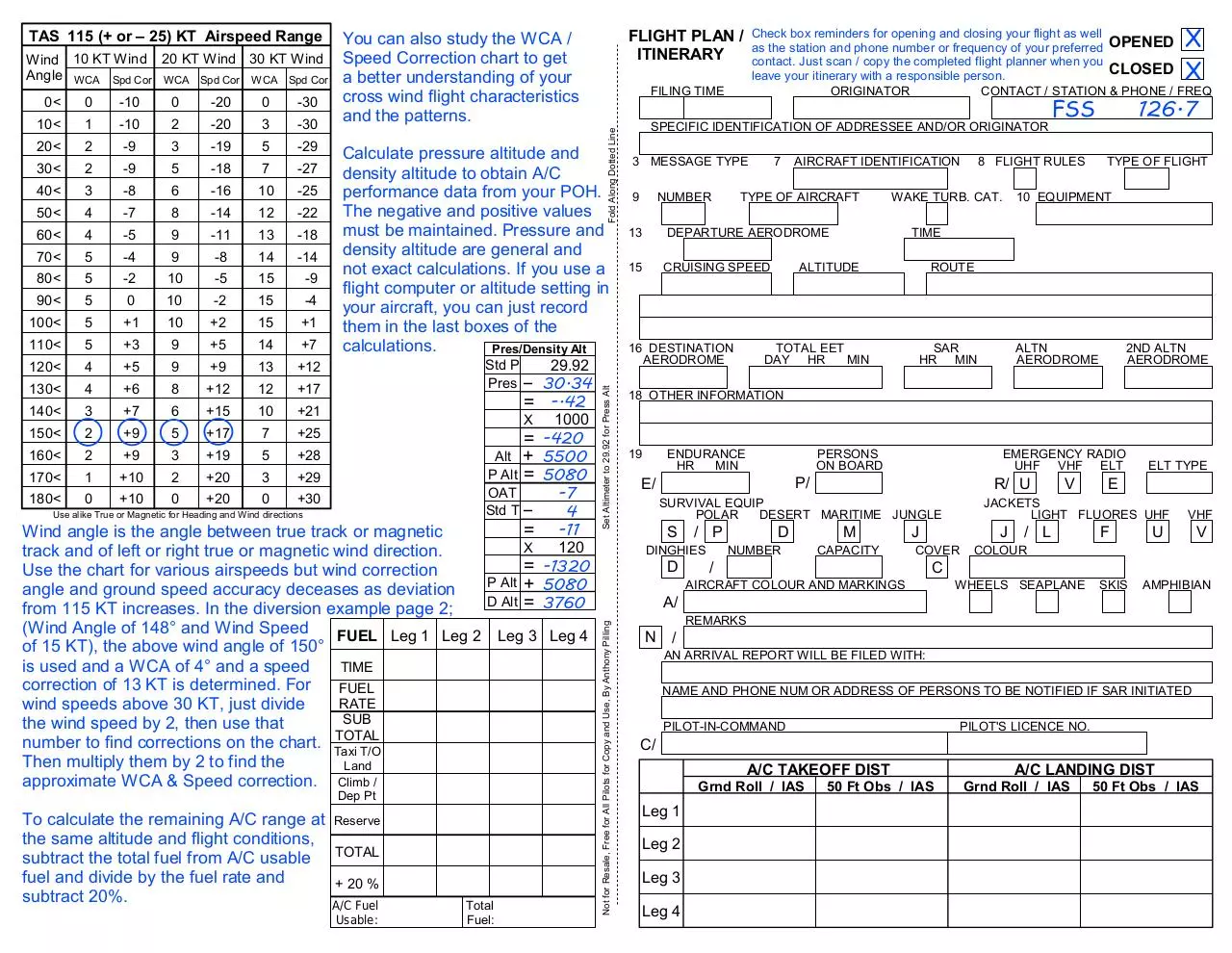
Calculate pressure altitude and
density altitude to obtain A/C
performance data from your POH.
The negative and positive values
must be maintained. Pressure and
density altitude are general and
not exact calculations. If you use a
flight computer or altitude setting in
your aircraft, you can just record
them in the last boxes of the
calculations.
Pres/Density Alt
Std P
29.92
Pres _ 30.34
= -.42
X
1000
= -420
Alt + 5500
P Alt = 5080
OAT
Std T _
Use alike True or Magnetic for Heading and Wind directions
-7
4
-11
120
-1320
5080
3760
=
Wind angle is the angle between true track or magnetic
X
track and of left or right true or magnetic wind direction.
=
Use the chart for various airspeeds but wind correction
P Alt +
angle and ground speed accuracy deceases as deviation
D
Alt =
from 115 KT increases. In the diversion example page 2;
(Wind Angle of 148° and Wind Speed
FUEL Leg 1 Leg 2 Leg 3 Leg 4
of 15 KT), the above wind angle of 150°
is used and a WCA of 4° and a speed
TIME
correction of 13 KT is determined. For
FUEL
RATE
wind speeds above 30 KT, just divide
SUB
the wind speed by 2, then use that
TOTAL
number to find corrections on the chart. Taxi T/O
Then multiply them by 2 to find the
Land
approximate WCA & Speed correction. Climb /
Dep Pt
To calculate the remaining A/C range at Reserve
the same altitude and flight conditions,
subtract the total fuel from A/C usable TOTAL
fuel and divide by the fuel rate and
+ 20 %
subtract 20%.
A/C Fuel
Usable:
Total
Fuel:
X
X
FILING TIME
Fold Along Dotted Line
0<
Set Altimeter to 29.92 for Press Alt
Wind 10 KT Wind 20 KT Wind 30 KT Wind
Angle WCA Spd Cor WCA Spd Cor WCA Spd Cor
Check box reminders for opening and closing your flight as well
as the station and phone number or frequency of your preferred OPENED
contact. Just scan / copy the completed flight planner when you
CLOSED
leave your itinerary with a responsible person.
ORIGINATOR
CONTACT / STATION & PHONE / FREQ
FLIGHT PLAN /
ITINERARY
You can also study the WCA /
Speed Correction chart to get
a better understanding of your
cross wind flight characteristics
and the patterns.
SPECIFIC IDENTIFICATION OF ADDRESSEE AND/OR ORIGINATOR
3 MESSAGE TYPE
9
NUMBER
7
AIRCRAFT IDENTIFICATION
TYPE OF AIRCRAFT
13
DEPARTURE AERODROME
15
CRUISING SPEED
16 DESTINATION
AERODROME
8 FLIGHT RULES
WAKE TURB. CAT.
126.7
FSS
TYPE OF FLIGHT
10 EQUIPMENT
TIME
ALTITUDE
ROUTE
TOTAL EET
DAY HR
MIN
SAR
HR MIN
ALTN
AERODROME
2ND ALTN
AERODROME
18 OTHER INFORMATION
19
ENDURANCE
HR
MIN
PERSONS
ON BOARD
EMERGENCY RADIO
UHF VHF ELT
P/
E/
R/ U
SURVIVAL EQUIP
POLAR
DESERT MARITIME JUNGLE
S
D
D
/ P
DINGHIES
NUMBER
M
CAPACITY
J
COVER
/
V
ELT TYPE
E
JACKETS
LIGHT FLUORES UHF
J
/ L
F
VHF
U
V
COLOUR
C
AIRCRAFT COLOUR AND MARKINGS
WHEELS SEAPLANE
SKIS
AMPHIBIAN
A/
Not for Resale, Free for All Pilots for Copy and Use, By Anthony Pilling
TAS 115 (+ or – 25) KT Airspeed Range
REMARKS
N
/
AN ARRIVAL REPORT WILL BE FILED WITH:
NAME AND PHONE NUM OR ADDRESS OF PERSONS TO BE NOTIFIED IF SAR INITIATED
PILOT-IN-COMMAND
PILOT'S LICENCE NO.
C/
A/C TAKEOFF DIST
Grnd Roll / IAS
Leg 1
Leg 2
Leg 3
Leg 4
50 Ft Obs / IAS
A/C LANDING DIST
Grnd Roll / IAS
50 Ft Obs / IAS
Download Pilling Pilot Navigation Flight Planner Canada Instructions
Pilling Pilot Navigation Flight Planner Canada Instructions.pdf (PDF, 150.58 KB)
Download PDF
Share this file on social networks
Link to this page
Permanent link
Use the permanent link to the download page to share your document on Facebook, Twitter, LinkedIn, or directly with a contact by e-Mail, Messenger, Whatsapp, Line..
Short link
Use the short link to share your document on Twitter or by text message (SMS)
HTML Code
Copy the following HTML code to share your document on a Website or Blog
QR Code to this page

This file has been shared publicly by a user of PDF Archive.
Document ID: 0000702692.