D21.01 (PDF)
File information
Title: «Point_ID»
Author: kshearer
This PDF 1.4 document has been generated by Acrobat PDFMaker 6.0 for Word / Acrobat Distiller 6.0 (Windows), and has been sent on pdf-archive.com on 19/12/2017 at 14:37, from IP address 205.141.x.x.
The current document download page has been viewed 148 times.
File size: 46.8 KB (1 page).
Privacy: public file
File preview
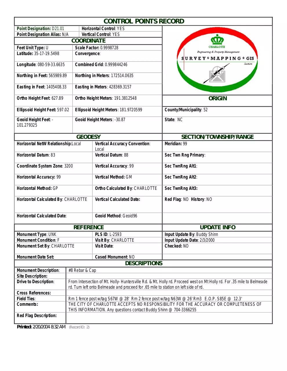
CONTROL POINTS RECORD
Point Designation: D21.01
Point Designation Alias: N/A
Horizontal Control: YES
Vertical Control: YES
COORDINATE
Feet Unit Type: U
Latitude: 35-17-19.5498
Scale Factor: 0.9998728
Convergence:
Longitude: 080-59-33.6635
Combined Grid: 0.999844246
Northing in Feet: 565989.89
Northing in Meters: 172514.0635
Easting in Feet: 1405408.33
Easting in Meters: 428369.3157
Ortho Height Feet: 627.89
Ortho Height Meters: 191.3812548
Ellipsoid Height Feet: 597.02
Ellipsoid Height Meters: 181.9720599
County/Municipality: 52
Geoid Height Feet: 101.279325
Geoid Height Meters: -30.87
State: NC
GEODESY
Horizontal NetW Relationship:Local
ORIGIN
SECTION/TOWNSHIP/RANGE
Meridian: 99
Horizontal Datum: 83
Vertical Accuracy Convention:
Local
Vertical Datum: 88
Coordinate System Zone: 3200
Vertical Accuracy: 99
Sec TwnRng Alt1:
Horizontal Accuracy: 99
Vertical Method: GM
Sec TwnRng Alt2:
Horizontal Method: GP
Ortho Calculated By: CHARLOTTE
Sec TwnRng Alt3:
Horizontal Calculated By: CHARLOTTE
Vertical Calculated Date:
Red Flag: NO History: NO
Horizontal Calculated Date:
Geoid Method: Geoid96
REFERENCE
Sec Twn Rng Primary:
UPDATE INFO
Monument Type: UNK
Monument Condition: F
Monument Set By: CHARLOTTE
PLS ID: L-2593
Visit By: CHARLOTTE
Visit Date:
Monument Date Set:
Cased Monument: NO
Input Update By: Buddy Shinn
Input Update Date: 2/3/2000
Checked: NO
DESCRIPTIONS
Monument Description:
Site Description:
Drive to Description:
Cross References:
Field Ties:
Comments:
#8 Rebar & Cap
From Intersection of Mt. Holly- Huntersville Rd. & Mt. Holly rd. Proceed west on Mt Holly rd. For .35 mile to Belmeade
rd. Turn left onto Belmeade and proceed for .65 mile to station on left side of rd.
Rm 1 fence post w/tag S67W @ 28' Rm 2 fence post w/tag N63W @ 26' Rm3 E.O.P. S85E @ 12.3'
THE CITY OF CHARLOTTE ACCEPTS NO RESPONSIBILITY FOR THE ACCURACY OR COMPLETENESS OF
THIS INFORMATION. Any questions contact Buddy Shinn @ 704-3366255
Red Flag Description:
Printed: 2/20/2004 8:32 AM
(Record ID: 2)
Download D21.01
D21.01.pdf (PDF, 46.8 KB)
Download PDF
Share this file on social networks
Link to this page
Permanent link
Use the permanent link to the download page to share your document on Facebook, Twitter, LinkedIn, or directly with a contact by e-Mail, Messenger, Whatsapp, Line..
Short link
Use the short link to share your document on Twitter or by text message (SMS)
HTML Code
Copy the following HTML code to share your document on a Website or Blog
QR Code to this page

This file has been shared publicly by a user of PDF Archive.
Document ID: 0000710219.