ports (PDF)
File information
Title: List of ports in Australia - Wikipedia
Author: george
This PDF 1.3 document has been generated by e-PDF Converter and Creator v2.1 - Build: Jul 22 2009 / e-PDF Converter and Creator (http://www.e-pdfconverter.com), and has been sent on pdf-archive.com on 20/11/2017 at 02:31, from IP address 124.170.x.x.
The current document download page has been viewed 346 times.
File size: 72.46 KB (10 pages).
Privacy: public file


File preview
List of ports in Australia - Wikipedia
1 of 10
https://en.wikipedia.org/wiki/List_of_ports_in_Australia
List of ports in Australia
This is a list of ports in Australia. It includes all gazetted ports, harbours, havens, roadsteads and marinas.
This list is complete with respect to the 1996 Gazetteer of Australia.[1] Dubious names have been checked against the
online 2004 data,[2] and in all cases confirmed correct. However, if any ports have been gazetted or deleted since 1996,
this list does not reflect these changes. Strictly speaking, Australian place names are gazetted in capital letters only;
the names in this list have been converted to mixed case in accordance with normal capitalisation conventions.
Locations are as gazetted; obviously some islands may extend over large areas.
The list also contains some entries for places that are widely recognised as ports or harbours, yet have not been
gazetted as such. These are noted and individually referenced in the list.
Contents
1
New South Wales
2
Northern Territory
3
Queensland
4
South Australia
5
Tasmania
6
Victoria
7
Western Australia
8
See also
9
References
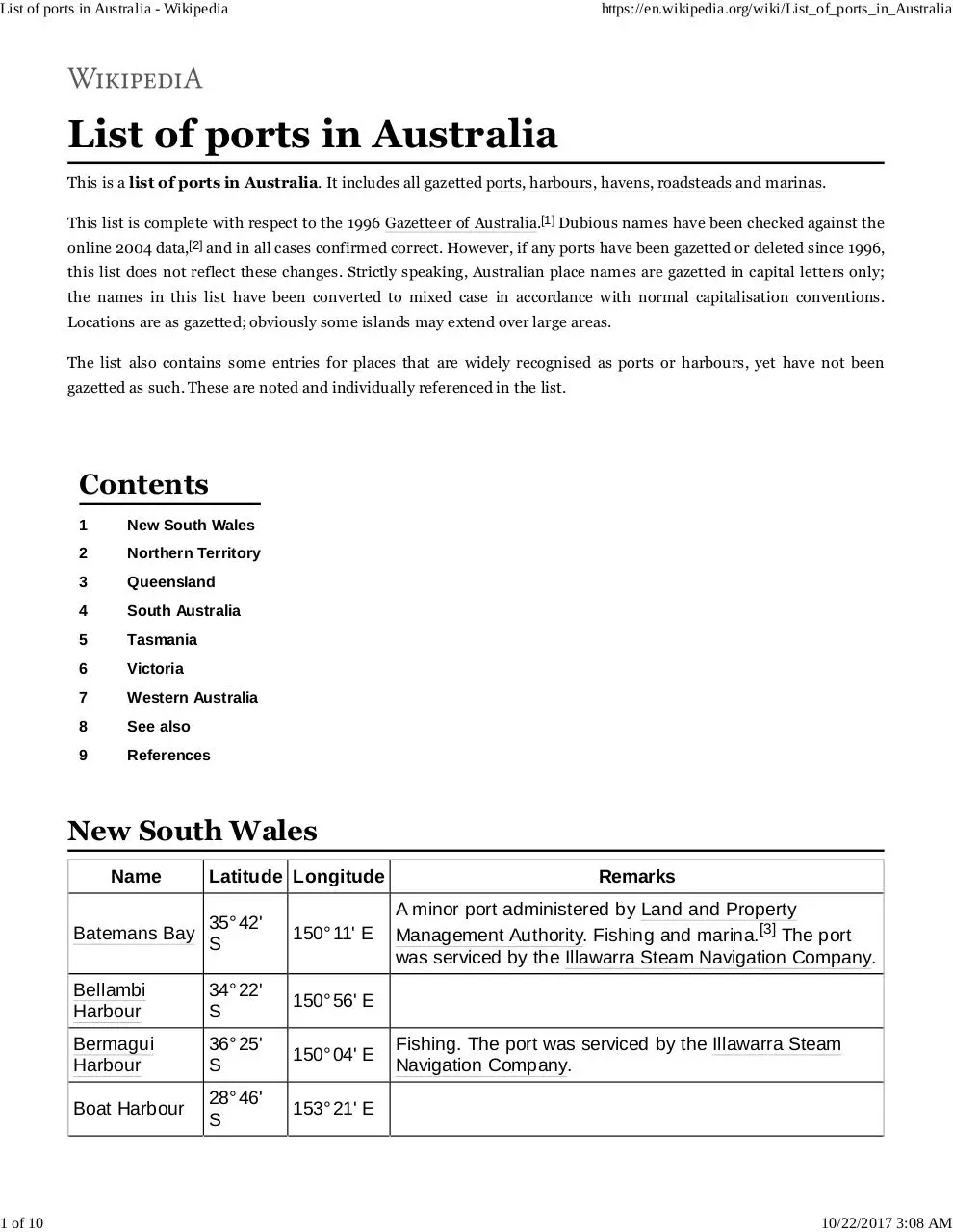
New South Wales
Name
Latitude Longitude
Batemans Bay
35° 42'
S
150° 11' E
Bellambi
Harbour
34° 22'
S
150° 56' E
Bermagui
Harbour
36° 25'
S
150° 04' E
Boat Harbour
28° 46'
S
153° 21' E
Remarks
A minor port administered by Land and Property
Management Authority. Fishing and marina.[3] The port
was serviced by the Illawarra Steam Navigation Company.
Fishing. The port was serviced by the Illawarra Steam
Navigation Company.
10/22/2017 3:08 AM
List of ports in Australia - Wikipedia
2 of 10
https://en.wikipedia.org/wiki/List_of_ports_in_Australia
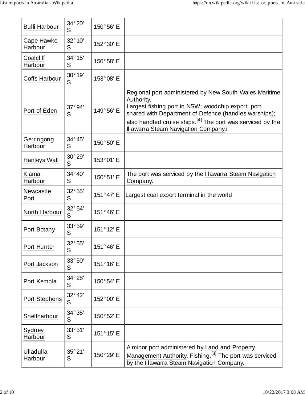
Bulli Harbour
34° 20'
S
150° 56' E
Cape Hawke
Harbour
32° 10'
S
152° 30' E
Coalcliff
Harbour
34° 15'
S
150° 58' E
Coffs Harbour
30° 19'
S
153° 08' E
Regional port administered by New South Wales Maritime
Authority.
Largest fishing port in NSW; woodchip export; port
shared with Department of Defence (handles warships);
also handled cruise ships.[4] The port was serviced by the
Illawarra Steam Navigation Company.i
Port of Eden
37° 94'
S
149° 56' E
Gerringong
Harbour
34° 45'
S
150° 50' E
Hanleys Wall
30° 29'
S
153° 01' E
Kiama
Harbour
34° 40'
S
150° 51' E
Newcastle
Port
32° 55'
S
151° 47' E Largest coal export terminal in the world
North Harbour
32° 54'
S
151° 46' E
Port Botany
33° 59'
S
151° 12' E
Port Hunter
32° 55'
S
151° 46' E
Port Jackson
33° 50'
S
151° 16' E
Port Kembla
34° 28'
S
150° 54' E
Port Stephens
32° 42'
S
152° 00' E
Shellharbour
34° 35'
S
150° 52' E
Sydney
Harbour
33° 51'
S
151° 15' E
Ulladulla
Harbour
35° 21'
S
150° 29' E
The port was serviced by the Illawarra Steam Navigation
Company.
A minor port administered by Land and Property
Management Authority. Fishing.[3] The port was serviced
by the Illawarra Steam Navigation Company.
10/22/2017 3:08 AM
List of ports in Australia - Wikipedia
3 of 10
Wollongong
Harbour
34° 25'
S
29° 26'
Port of Yamba
S
https://en.wikipedia.org/wiki/List_of_ports_in_Australia
150° 54' E
The port was serviced by the Illawarra Steam Navigation
Company.
153° 22' E
Regional port administered by New South Wales Maritime
Authority. Timber exports; regular general cargo services
to Lord Howe Island, Norfolk Island, and New Zealand.[5]
Northern Territory
Name
Bynoe Harbour
Curtis Haven
Gove Peninsula
Port Bradshaw
Port Bremer
Port Cockburn
Port Daly
Port Darwin
Port Essington
Port Hurd
Port Keats
Port Langdon
Port Mcarthur
Port Patterson
Queensland
Name
Latitude Longitude Remarks
Port of Brisbane
27° 23 ′ S 153° 10 ′ E
Abbot Point
19° 53 ′ S 148° 5 ′ E
Bowen
20° 4' S
Bundaberg Port
24° 45' S 152° 24' E
Cairns Harbour
16° 54' S 145° 47' E
Cid Harbour
20° 15' S 148° 56' E
Port Clinton
22° 30' S 150° 45' E
Port Denison
20° 2' S
Port Douglas
16° 29' S 145° 28' E
Dungeness Harbour
18° 31' S 146° 19' E
148° 21' E
148° 15' E
10/22/2017 3:08 AM
List of ports in Australia - Wikipedia
4 of 10
https://en.wikipedia.org/wiki/List_of_ports_in_Australia
Flattery Harbour
14° 54' S 145° 17' E
Port of Gladstone
23° 50' S 151° 35' E
Hay Point Harbour
21° 13' S 149° 20' E
Hay Point Port
21° 13' S 149° 20' E
Hope Harbour
27° 52' S 153° 22' E
Innisfail Harbour
17° 42' S 146° 9' E
Port Lihou
10° 45' S 142° 11' E
Mackay
21° 10' S 149° 14' E
Mackay Harbour
21° 8' S
Manly Boat Harbour
27° 27' S 153° 11' E
Port Molle
20° 20' S 148° 50' E
Mooloolaba Boat Harbour
26° 41' S 153° 8' E
Mourilyan Harbour
17° 37' S 146° 7' E
Port Musgrave
12° 1' S
Port Newry
20° 51' S 148° 57' E
Outer Harbour
21° 6' S
149° 14' E
Philip Harbour
9° 58' S
142° 12' E
Port Alma
23° 35' S 150° 52' E
Portland Roads
12° 36' S 143° 25' E
Rodds Harbour
24° 2' S
149° 15' E
141° 57' E
151° 37' E
Scarborough Boat Harbour 27° 12' S 153° 6' E
Snug Harbour
19° 46' S 147° 51' E
Shute Harbour
20° 17' S 148° 47' E
Port Stewart
14° 4' S
Toondah Harbour
27° 32' S 153° 17' E
Wide Bay Harbour
25° 47' S 153° 0' E
143° 41' E
South Australia
Name
Latitude
Longitude
Port Alfred
34° 36' S
137° 53' E
Port Ardrossan
34° 26' S
137° 55' E
Augusta Harbor
32° 46' S
134° 13' E
Port Augusta
32° 30' S
133° 45' E
B.H.P Shipping Port
34° 45' S
135° 53' E
Remarks
10/22/2017 3:08 AM
List of ports in Australia - Wikipedia
5 of 10
https://en.wikipedia.org/wiki/List_of_ports_in_Australia
Ballast Head Harbor
35° 46' S
137° 48' E
Blanche Port
32° 46' S
134° 13' E
Boat Harbor
35° 31' S
138° 13' E
Port Bonython
32° 59 ′ 30″ S 137° 45 ′ 50″ E Panamax plus ; oil (iron ore proposed)
Port Caroline
36° 50' S
139° 50' E
Port Champagny
34° 44' S
135° 56' E
Port Eyre
32° 00' S
132° 27' E
Fishing Boat Harbor
32° 09' S
133° 39' E
Flinders Lake
33° 43' S
136° 57' E
Franklin Harbor
33° 43' S
136° 57' E
Port Giles
35° 02 ′ S
137° 46 ′ E
Port Glenelg
35° 01' S
138° 30' E
Port Hughes
34° 04' S
137° 33' E
Port Irvine
32° 05' S
132° 59' E
Kingscote Harbour
35° 39' S
137° 40' E
Port Le Hunte
32° 06' S
133° 00' E
Port Lincoln
34° 44' S
135° 56' E
Mcleod Harbor
35° 07' S
137° 31' E
Port Milang
35° 26' S
138° 59' E
Port Mobilong
35° 07' S
139° 17' E
Port Moonta
34° 03' S
137° 33' E
Port Neill
34° 07' S
136° 21' E
Port Noarlunga
35° 09' S
138° 28' E
Outer Harbor
34° 47' S
138° 28' E
Port Parnanga
35° 07' S
138° 28' E
Patawalonga Boat Haven
34° 58' S
138° 31' E
Port Augusta Harbor
32° 30' S
137° 46' E
Port Blanche
32° 46' S
134° 13' E
Port Edithburg
35° 04' S
137° 46' E
Port Edithburgh
35° 04' S
137° 46' E
Port of Wool Bay
35° 00' S
137° 46' E
Ports Grey and Beachport 37° 32' S
140° 04' E
Port Pullen
35° 33' S
138° 53' E
Port Rickaby
34° 39' S
137° 29' E
Panamax plus ; c1970 ; grain
Panamax plus ; grain & iron ore
10/22/2017 3:08 AM
List of ports in Australia - Wikipedia
6 of 10
https://en.wikipedia.org/wiki/List_of_ports_in_Australia
Rosetta Harbor
35° 35' S
138° 36' E
Port Stansbury
34° 53' S
137° 49' E
Port Stanvac
35° 7' S
138° 28' E
Stenhouse Bay Harbor
35° 16' S
136° 57' E
Thevenard Harbor
32° 07' S
133° 38' E
Victor Harbor
35° 34' S
138° 38' E
Port Victoria
34° 29' S
137° 26' E
Port Vincent
34° 46' S
137° 52' E
Port Vincent
34° 44' S
137° 53' E
Port Warrenne
34° 19' S
137° 30' E
Whyalla Harbor
33° 01' S
137° 36' E
Port of Whyalla
33° 02' S
137° 37' E
Port Willunga
35° 18' S
138° 25' E
Port Wool Bay
35° 00' S
137° 46' E
Port Yankalilla
35° 26' S
138° 19' E
Panamax plus ; grain & iron ore
Tasmania
Name
Latitude Longitude Remarks
Amy Harbour
43° 33' S 146° 6' E
Bathurst Harbour
43° 21' S 146° 11' E
Bell Bay Harbour
39° 51' S 147° 47' E
Conical Harbour
41° 42' S 144° 55' E
Currie Harbour
39° 56' S 143° 50' E
Port Dalrymple
41° 8' S
East Boat Harbour
40° 45' S 147° 57' E
Port Fenton
41° 10' S 146° 15' E
Granville Harbour
41° 49' S 145° 2' E
Grassy Harbour
40° 4' S
146° 49' E
144° 3' E
Jack Smiths Boat Harbour 40° 26' S 148° 3' E
Jacobs Boat Harbour
40° 56' S 145° 37' E
Macquarie Harbour
42° 18' S 145° 22' E
Port Maldon
41° 2' S
Manganna Boat Harbour
39° 42' S 147° 54' E
New Harbour
43° 31' S 146° 9' E
145° 50' E
10/22/2017 3:08 AM
List of ports in Australia - Wikipedia
7 of 10
https://en.wikipedia.org/wiki/List_of_ports_in_Australia
Opossum Boat Harbour
40° 13' S 148° 16' E
Parishs Boat Harbour
41° 2' S
Porky Boat Harbour
40° 22' S 148° 1' E
Rowitta Harbour
43° 19' S 146° 11' E
Port Sorell
41° 12' S 146° 34' E
Southport
43° 27' S 146° 59' E
Stanley Harbour
40° 46' S 145° 18' E
Strahan Harbour
42° 9' S
Temma Harbour
41° 14' S 144° 41' E
Trial Harbour
41° 56' S 145° 10' E
145° 53' E
145° 20' E
Victoria
Name
Latitude Longitude Remarks
Anderson Harbour
37° 13' S 145° 54' E
Bagge Harbour
38° 16' S 145° 18' E
Bass Landing
38° 30' S 145° 27' E
Bentley Harbour
38° 47' S 146° 31' E
Gabo Harbour
37° 34' S 149° 55' E
Outer Harbour
38° 7' S
144° 29' E
Reedy Harbour
38° 8' S
147° 20' E
Saint Kilda Marina
37° 53' S 144° 58' E
Warrnambool Harbour
38° 24' S 142° 29' E
Westhaven Boat Harbour 38° 19' S 145° 12' E
Western Australia
Name
Latitude Longitude
Albany Port
35° 2' S
117° 54' E
Balla Balla Harbour
20° 40'
S
117° 47' E
Batavia Coast Boat
Harbour
28° 46'
S
114° 37' E
Boat Harbour
35° 2' S
117° 4' E
Brecknock Harbour
15° 28'
S
124° 33' E
Remarks
10/22/2017 3:08 AM
List of ports in Australia - Wikipedia
8 of 10
https://en.wikipedia.org/wiki/List_of_ports_in_Australia
Port of Bunbury
33° 20'
S
115° 38' E
Butty Harbour
33° 52'
S
121° 40' E
Camden Harbour
15° 30'
S
124° 36' E
Challenger Harbour
32° 4' S
115° 44' E
Condon
20° 0' S
119° 23' E
Abandoned following development of Port
Hedland
Cossack
20° 41'
S
117° 11' E
Historic pioneer port for Roebourne
Dampier Port
20° 40'
S
116° 42' E Railway for iron ore, etc. export
Esperance Port
33° 52'
S
121° 53' E Railway for iron ore and wheat export
Fishing Boat Harbour
32° 4' S
115° 45' E
Fremantle Harbour
32° 3' S
115° 44' E General commercial port
Port George IV
15° 22'
S
124° 40' E
Port of Geraldton
28° 47'
S
114° 36' E Railway for iron ore and wheat export
Geranium Harbour
13° 55'
S
126° 33' E
Port Gregory
28° 11' S 114° 15' E Originally called Boat Harbour
Port Grey
28° 48'
S
114° 36' E
Port Harding
35° 4' S
117° 39' E Torbay
Port Hedland
20° 19'
S
118° 36' E Railway for iron ore export
Henri Freycinet Harbour
26° 19'
S
113° 41' E
Hillarys Boat Harbour
31° 49'
S
115° 44' E
Port Hughes
35° 3' S
117° 41' E Torbay
Jurien Boat Harbour
30° 17'
S
115° 2' E
Port Kennedy
32° 22'
S
115° 44' E
Little Boat Harbour
34° 28'
S
119° 22' E
10/22/2017 3:08 AM
List of ports in Australia - Wikipedia
9 of 10
https://en.wikipedia.org/wiki/List_of_ports_in_Australia
Mandurah Ocean
Marina
32° 32'
S
115° 43' E
Mary Ann Haven
33° 58'
S
120° 7' E
Nanarup Boat Harbour
35° 0' S
118° 4' E
Port Nelson
15° 5' S
125° 1' E
Ocean Reef Boat
Harbour
31° 46'
S
115° 44' E
Oyster Harbour
34° 58'
S
117° 57' E
Parry Harbour
14° 1' S
126° 5' E
Prince Frederick
Harbour
15° 3' S
125° 17' E
Princess Royal Harbour 35° 3' S
117° 53' E More commonly know n as Albany Port
Port Robinson
20° 39'
S
117° 2' E
Rous Head Harbour
32° 3' S
115° 44' E
Point Samson
20° 38'
S
117° 12' E
Port Smith
18° 30'
S
121° 47' E
Starvation Boat Harbour
33° 55'
S
120° 34' E
Success Boat Harbour
32° 4' S
115° 45' E
Tagon Harbour
33° 53'
S
122° 59' E
Taylor Boat Harbour
33° 55'
S
122° 50' E
Port Usborne
16° 39'
S
123° 29' E
Victoria Harbour
(Western Australia)
33° 56'
S
122° 30' E
Port Walcott
20° 39'
S
117° 11' E
Port Warrender
14° 32'
S
125° 53' E
Port Weld
21° 23'
S
115° 33' E
Fishing port; formerly used for Australian Blue
Asbestos shiploading.
Includes the deep-water wharves at Cape
Lambert; Point Samson; and Cossack
10/22/2017 3:08 AM
Download ports
ports.pdf (PDF, 72.46 KB)
Download PDF
Share this file on social networks
Link to this page
Permanent link
Use the permanent link to the download page to share your document on Facebook, Twitter, LinkedIn, or directly with a contact by e-Mail, Messenger, Whatsapp, Line..
Short link
Use the short link to share your document on Twitter or by text message (SMS)
HTML Code
Copy the following HTML code to share your document on a Website or Blog
QR Code to this page

This file has been shared publicly by a user of PDF Archive.
Document ID: 0000698828.