Sewickley Heights trail map (PDF)
File information
Author: user
This PDF 1.5 document has been generated by Microsoft® Publisher 2013, and has been sent on pdf-archive.com on 04/02/2017 at 15:53, from IP address 72.23.x.x.
The current document download page has been viewed 495 times.
File size: 1.97 MB (1 page).
Privacy: public file
File preview
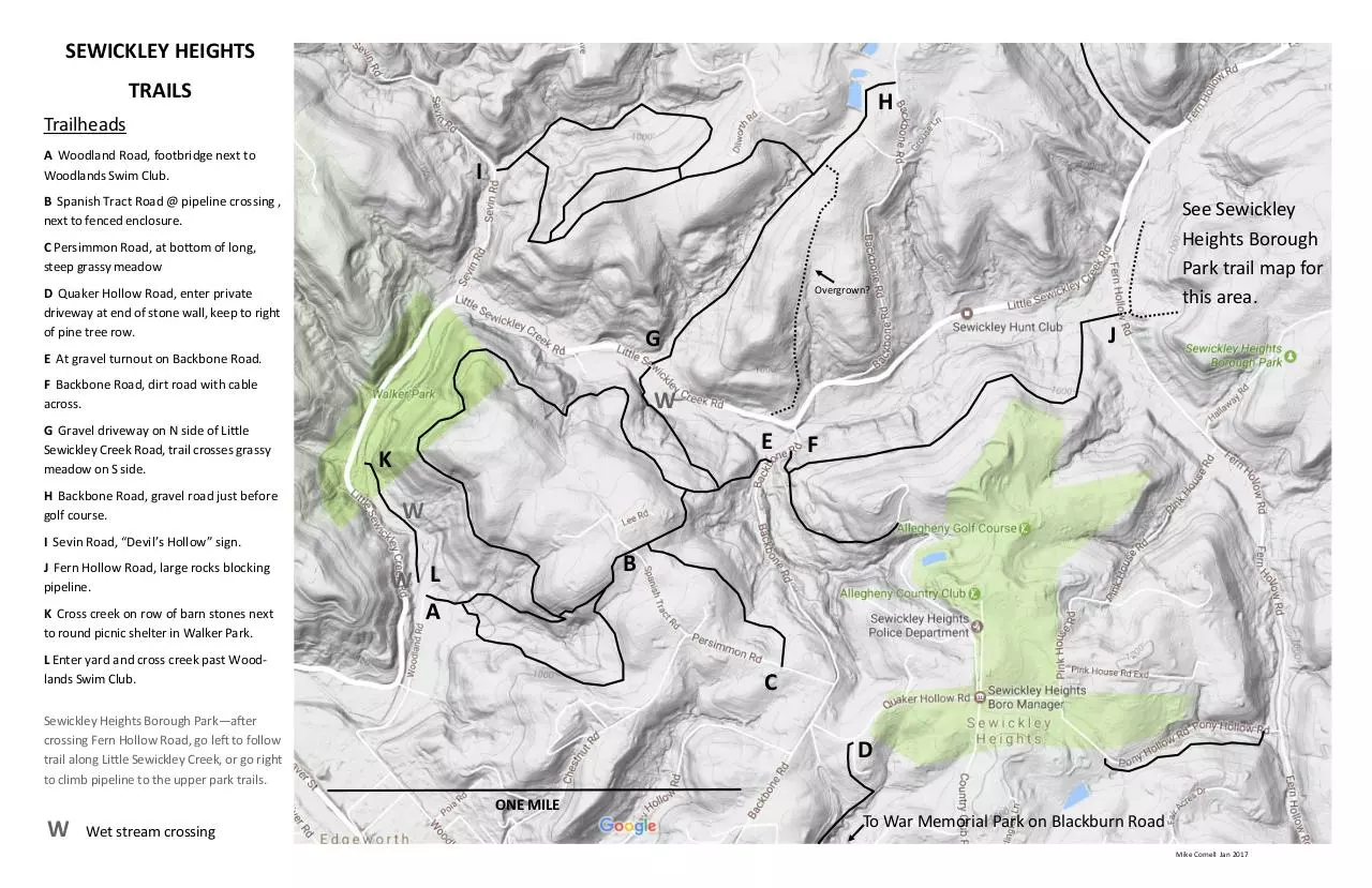
SEWICKLEY HEIGHTS
TRAILS
H
Trailheads
A Woodland Road, footbridge next to
Woodlands Swim Club.
I
B Spanish Tract Road @ pipeline crossing ,
next to fenced enclosure.
See Sewickley
Heights Borough
Park trail map for
this area.
C Persimmon Road, at bottom of long,
steep grassy meadow
Overgrown?
D Quaker Hollow Road, enter private
driveway at end of stone wall, keep to right
of pine tree row.
J
G
E At gravel turnout on Backbone Road.
F Backbone Road, dirt road with cable
across.
G Gravel driveway on N side of Little
Sewickley Creek Road, trail crosses grassy
meadow on S side.
H Backbone Road, gravel road just before
golf course.
W
E
K
F
W
I Sevin Road, “Devil’s Hollow” sign.
J Fern Hollow Road, large rocks blocking
pipeline.
K Cross creek on row of barn stones next
to round picnic shelter in Walker Park.
B
W L
A
L Enter yard and cross creek past Woodlands Swim Club.
C
Sewickley Heights Borough Park—after
crossing Fern Hollow Road, go left to follow
trail along Little Sewickley Creek, or go right
to climb pipeline to the upper park trails.
D
ONE MILE
W
Wet stream crossing
To War Memorial Park on Blackburn Road
Mike Cornell Jan 2017
Download Sewickley Heights trail map
Sewickley Heights trail map.pdf (PDF, 1.97 MB)
Download PDF
Share this file on social networks
Link to this page
Permanent link
Use the permanent link to the download page to share your document on Facebook, Twitter, LinkedIn, or directly with a contact by e-Mail, Messenger, Whatsapp, Line..
Short link
Use the short link to share your document on Twitter or by text message (SMS)
HTML Code
Copy the following HTML code to share your document on a Website or Blog
QR Code to this page

This file has been shared publicly by a user of PDF Archive.
Document ID: 0000548914.