TripTik® Overview Map
TripTik® Overview Directions
From: 1799 Ridgeside Drive, Mt Airy 21771, Maryland
To:
8857 Mcgaw Road, Columbia 21045, Maryland
Total Distance:
45.7 miles (73.5km)
Total Estimated Time: 1 hrs., 37mins.
Directions
1799 Ridgeside Drive, Mt Airy 21771, Maryland to Ilchester
Road, Ellicott City 21043, Maryland
Distance: 37.4 miles (60.2km) Time: 1 hrs., 14mins.
1. Start out heading SOUTHWEST on RIDGESIDE DRIVE towards
MAIN STREET. Drive for a short distance.
2. Turn LEFT onto MAIN STREET. Drive for a short distance.
3. Turn LEFT onto MD-27 N. Drive for 8 miles.
4. Turn LEFT onto an access street. Drive for 0.1 miles.
5. Make a U-turn. Drive for 0.1 miles.
6. Turn LEFT onto RIDGE ROAD. Drive for 0.1 miles.
7. Turn RIGHT onto W LIBERTY ROAD. Drive for 9.2 miles.
5 mi
10 km
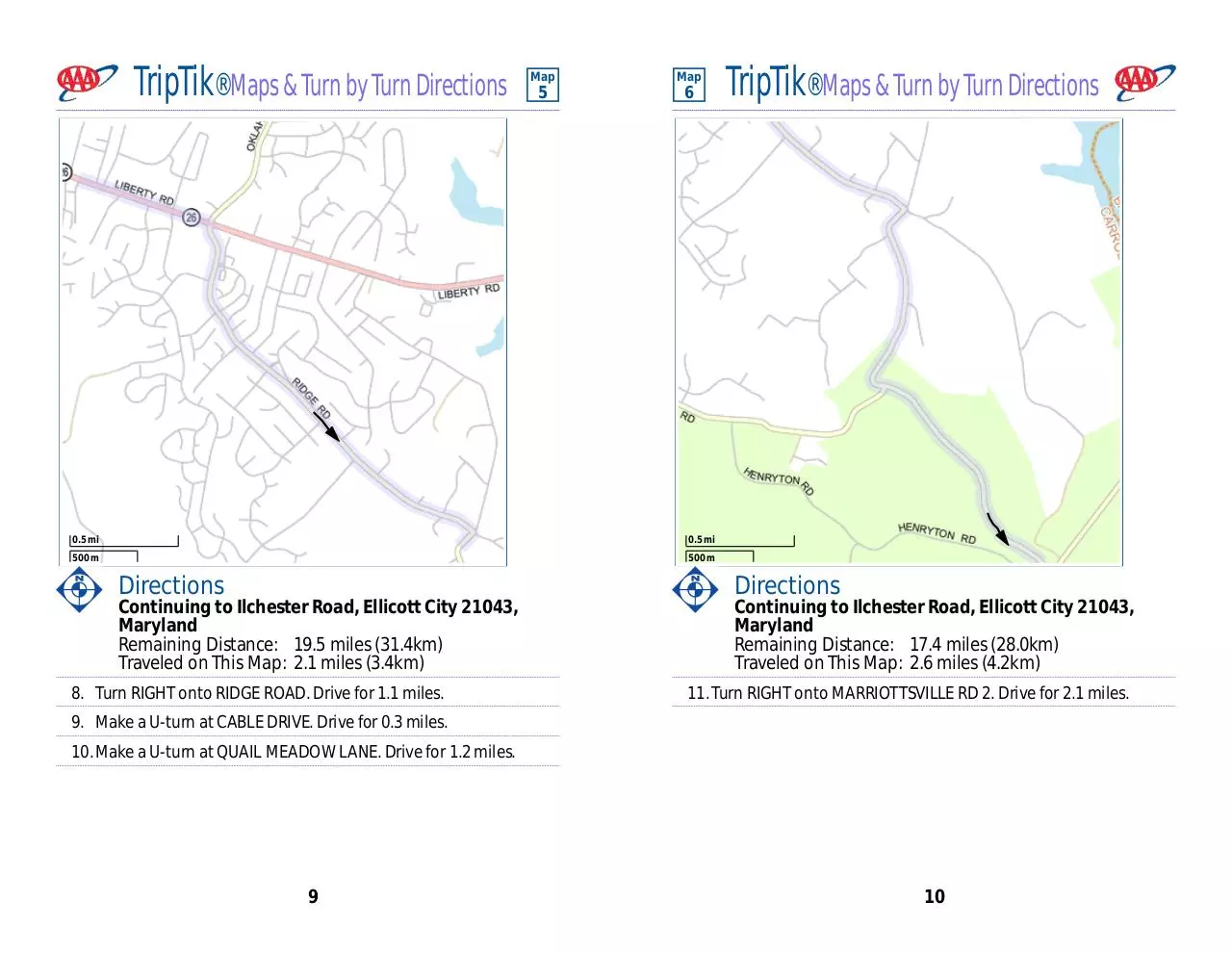
8. Turn RIGHT onto RIDGE ROAD. Drive for 1.1 miles.
Legend
Trip Origin
Trip Destination
Stopover
Controlled Access
Toll
Primary
Secondary
Local
Unpaved
Tunnel
Ferry, Auto
Ferry, Passenger
Interstate
AAA Travel Information
TransCanadian Hwy
On Map:
Canadian Autoroute
Scenic Byway
US Highway
Construction
State/Provincial Route
New Road
County/Local Route
Details:
Rest Area with facilities
Construction Info
Rest Area without facilities
Bridge and Ferry Info
Service Plaza
Advisory
Welcome Center
See detailed TripTik Scenic
Information after the last Map/
Exit Number
Directions page
Gas, Food, Lodging
AAA Approved
Restaurants/Lodging
©2010 AAA, ESRI, NAVTEQ, TCS
9. Make a U-turn at CABLE DRIVE. Drive for 0.3 miles.
10. Make a U-turn at QUAIL MEADOW LANE. Drive for 1.2 miles.
11. Turn RIGHT onto MARRIOTTSVILLE RD 2. Drive for 2.1 miles.
12. Turn RIGHT onto MARRIOTTSVILLE ROAD. Drive for 3.7 miles.
13. Turn LEFT to get on I-70 E towards BALTIMORE. Drive for 3.8 miles.
14. Take exit number 87A on your RIGHT to get on US-29 S towards
COLUMBIA / WASHINGTON. Drive for 1.5 miles.
15. Take exit number 24A on your RIGHT to get on US-40 E towards
ELLICOTT CITY. Drive for 0.6 miles.
(continued on next page)
These directions are provided solely as a guideline. No representation is made or warranty given as to their content, route, practicability or
efficiency. User assumes all risk of use. AAA and its suppliers assume no responsibility for any loss or delay from use.
2
�
TripTik® Overview Directions
(continued from previous page)
16. Turn RIGHT onto RIDGE ROAD. Drive for 0.3 miles.
17. Turn RIGHT onto PATAPSCO RIVER ROAD. Drive for 0.4 miles.
18. Turn RIGHT onto ROGERS AVENUE. Drive for 0.2 miles.
19. Make a U-turn at SMITH AVENUE. Drive for a short distance.
20. Make a U-turn at RUSTY RIM. Drive for 0.1 miles.
21. Turn LEFT onto FREDERICK ROAD. Drive for 0.5 miles.
TripTik® Overview Directions
(continued from previous page)
36. Take exit number 3 on your RIGHT to get on SNOWDEN RIVER
PARKWAY. Drive for 0.6 miles.
37. Make a U-turn. Drive for 0.1 miles.
38. Make a U-turn at MD-108. Drive for 2 miles.
39. Turn RIGHT onto MCGAW ROAD. Drive for 0.2 miles.
40. You have reached 8857 Mcgaw Road, Columbia 21045, Maryland
22. FREDERICK ROAD becomes MAIN STREET. Drive for 0.3 miles.
23. Turn RIGHT onto MARYLAND AVENUE. Drive for a short distance.
24. Turn RIGHT onto ST PAUL STREET. Drive for 0.1 miles.
25. Turn LEFT onto COLLEGE AVENUE. Drive for 2 miles.
26. Turn LEFT onto BONNIE BRANCH ROAD. Drive for 0.6 miles.
27. Turn LEFT onto ILCHESTER ROAD. Drive for 0.1 miles.
28. You have reached Ilchester Road, Ellicott City 21043, Maryland
Ilchester Road, Ellicott City 21043, Maryland to 8857
Mcgaw Road, Columbia 21045, Maryland
Distance: 8.3 miles (13.4km) Time: 0 hrs., 22mins.
29. Start out heading SOUTHWEST on ILCHESTER ROAD towards
BONNIE BRANCH ROAD. Drive for 0.1 miles.
30. Turn RIGHT onto BONNIE BRANCH ROAD. Drive for 2.2 miles.
31. Turn RIGHT onto MONTGOMERY ROAD. Drive for 0.7 miles.
32. Turn LEFT onto MD-104. Drive for 0.9 miles.
33. Take the roundabout and exit at the SECOND street onto
MD-104. Drive for 0.1 miles.
34. Turn RIGHT onto MD-108. Drive for 0.1 miles.
35. Turn SLIGHT RIGHT to get on MD-100 E. Drive for 1 mile.
(continued on next page)
3
4
�
TripTik® Maps & Turn by Turn Directions
Map
Map
1
2
1000 ft
2 mi
500 m
2 km
Directions
1799 Ridgeside Drive, Mt Airy 21771, Maryland to
Ilchester Road, Ellicott City 21043, Maryland
Total Distance: 37.4 miles (60.2km)
Time: 1 hrs., 14mins.
Traveled on This Map: 1.1 miles (1.8km)
TripTik® Maps & Turn by Turn Directions
Directions
Continuing to Ilchester Road, Ellicott City 21043,
Maryland
Remaining Distance: 36.3 miles (58.4km)
Traveled on This Map: 7.2 miles (11.6km)
3a. Continue on MD-27 N.
1. Start out heading SOUTHWEST on RIDGESIDE DRIVE towards
MAIN STREET. Drive for a short distance.
2. Turn LEFT onto MAIN STREET. Drive for a short distance.
3. Turn LEFT onto MD-27 N. Drive for 8 miles.
5
6
�
TripTik® Maps & Turn by Turn Directions
Map
Map
3
4
1000 ft
2 mi
500 m
2 km
Directions
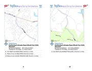
Continuing to Ilchester Road, Ellicott City 21043,
Maryland
Remaining Distance: 29.1 miles (46.8km)
Traveled on This Map: 1.1 miles (1.8km)
4. Turn LEFT onto an access street. Drive for 0.1 miles.
TripTik® Maps & Turn by Turn Directions
Directions
Continuing to Ilchester Road, Ellicott City 21043,
Maryland
Remaining Distance: 28.0 miles (45.1km)
Traveled on This Map: 8.6 miles (13.8km)
7a. Continue on W LIBERTY ROAD.
5. Make a U-turn. Drive for 0.1 miles.
Construction Info
6. Turn LEFT onto RIDGE ROAD. Drive for 0.1 miles.
» Construction/delays possible: SR-26; west of Baltimore at
junction with SR-97
7. Turn RIGHT onto W LIBERTY ROAD. Drive for 9.2 miles.
7
8
�
TripTik® Maps & Turn by Turn Directions
Map
Map
5
6
0.5 mi
0.5 mi
500 m
500 m
Directions
Continuing to Ilchester Road, Ellicott City 21043,
Maryland
Remaining Distance: 19.5 miles (31.4km)
Traveled on This Map: 2.1 miles (3.4km)
8. Turn RIGHT onto RIDGE ROAD. Drive for 1.1 miles.
TripTik® Maps & Turn by Turn Directions
Directions
Continuing to Ilchester Road, Ellicott City 21043,
Maryland
Remaining Distance: 17.4 miles (28.0km)
Traveled on This Map: 2.6 miles (4.2km)
11. Turn RIGHT onto MARRIOTTSVILLE RD 2. Drive for 2.1 miles.
9. Make a U-turn at CABLE DRIVE. Drive for 0.3 miles.
10. Make a U-turn at QUAIL MEADOW LANE. Drive for 1.2 miles.
9
10
�
TripTik® Maps & Turn by Turn Directions
Map
Map
7
8
0.5 mi
0.5 mi
500 m
500 m
Directions
Continuing to Ilchester Road, Ellicott City 21043,
Maryland
Remaining Distance: 14.8 miles (23.8km)
Traveled on This Map: 2.2 miles (3.5km)
12. Turn RIGHT onto MARRIOTTSVILLE ROAD. Drive for 3.7 miles.
11
TripTik® Maps & Turn by Turn Directions
Directions
Continuing to Ilchester Road, Ellicott City 21043,
Maryland
Remaining Distance: 12.6 miles (20.3km)
Traveled on This Map: 3.5 miles (5.6km)
13. Turn LEFT to get on I-70 E towards BALTIMORE. Drive for 3.8 miles.
12
�
TripTik® Maps & Turn by Turn Directions
Map
Map
9
10
1 mi
1000 ft
1 km
500 m
Directions
Continuing to Ilchester Road, Ellicott City 21043,
Maryland
Remaining Distance: 9.1 miles (14.6km)
Traveled on This Map: 3.6 miles (5.8km)
14. Take exit number 87A on your RIGHT to get on US-29 S towards
COLUMBIA / WASHINGTON. Drive for 1.5 miles.
TripTik® Maps & Turn by Turn Directions
Directions
Continuing to Ilchester Road, Ellicott City 21043,
Maryland
Remaining Distance: 5.5 miles (8.9km)
Traveled on This Map: 1.9 miles (3.1km)
15. Take exit number 24A on your RIGHT to get on US-40 E towards
ELLICOTT CITY. Drive for 0.6 miles.
16. Turn RIGHT onto RIDGE ROAD. Drive for 0.3 miles.
17. Turn RIGHT onto PATAPSCO RIVER ROAD. Drive for 0.4 miles.
18. Turn RIGHT onto ROGERS AVENUE. Drive for 0.2 miles.
(continued on next page)
13
14
�
TripTik® Maps & Turn by Turn Directions
Map
11
TripTik® Maps & Turn by Turn Directions
(continued from previous page)
19. Make a U-turn at SMITH AVENUE. Drive for a short distance.
20. Make a U-turn at RUSTY RIM. Drive for 0.1 miles.
21. Turn LEFT onto FREDERICK ROAD. Drive for 0.5 miles.
1000 ft
500 m
Directions
Continuing to Ilchester Road, Ellicott City 21043,
Maryland
Remaining Distance: 3.7 miles (6.0km)
Traveled on This Map: 1.6 miles (2.6km)
22. FREDERICK ROAD becomes MAIN STREET. Drive for 0.3 miles.
23. Turn RIGHT onto MARYLAND AVENUE. Drive for a short distance.
24. Turn RIGHT onto ST PAUL STREET. Drive for 0.1 miles.
25. Turn LEFT onto COLLEGE AVENUE. Drive for 2 miles.
15
16
�
TripTik® Maps & Turn by Turn Directions
Map
Map
12
13
1000 ft
1000 ft
500 m
500 m
Directions
Continuing to Ilchester Road, Ellicott City 21043,
Maryland
Remaining Distance: 2.1 miles (3.4km)
Traveled on This Map: 1.3 miles (2.1km)
26. Turn LEFT onto BONNIE BRANCH ROAD. Drive for 0.6 miles.
TripTik® Maps & Turn by Turn Directions
Directions
Continuing to Ilchester Road, Ellicott City 21043,
Maryland
Remaining Distance: 0.8 miles (1.3km)
Traveled on This Map: 0.8 miles (1.3km)
27. Turn LEFT onto ILCHESTER ROAD. Drive for 0.1 miles.
28. You have reached Ilchester Road, Ellicott City 21043, Maryland
17
18
�
TripTik® Maps & Turn by Turn Directions
Map
Map
14
15
1000 ft
1000 ft
500 m
500 m
Directions
Ilchester Road, Ellicott City 21043, Maryland to 8857
Mcgaw Road, Columbia 21045, Maryland
Total Distance: 8.3 miles (13.4km)
Time: 0 hrs., 22mins.
Traveled on This Map: 1.6 miles (2.6km)
29. Start out heading SOUTHWEST on ILCHESTER ROAD towards
BONNIE BRANCH ROAD. Drive for 0.1 miles.
TripTik® Maps & Turn by Turn Directions
Directions
Continuing to 8857 Mcgaw Road, Columbia 21045,
Maryland
Remaining Distance: 6.7 miles (10.8km)
Traveled on This Map: 2.0 miles (3.2km)
31. Turn RIGHT onto MONTGOMERY ROAD. Drive for 0.7 miles.
32. Turn LEFT onto MD-104. Drive for 0.9 miles.
30. Turn RIGHT onto BONNIE BRANCH ROAD. Drive for 2.2 miles.
19
20
�
TripTik® Maps & Turn by Turn Directions
Map
Map
16
17
1000 ft
1000 ft
500 m
500 m
Directions
Continuing to 8857 Mcgaw Road, Columbia 21045,
Maryland
Remaining Distance: 4.7 miles (7.6km)
Traveled on This Map: 1.8 miles (2.9km)
TripTik® Maps & Turn by Turn Directions
Directions
Continuing to 8857 Mcgaw Road, Columbia 21045,
Maryland
Remaining Distance: 3.0 miles (4.8km)
Traveled on This Map: 1.4 miles (2.3km)
33. Take the roundabout and exit at the SECOND street onto
MD-104. Drive for 0.1 miles.
36. Take exit number 3 on your RIGHT to get on SNOWDEN RIVER
PARKWAY. Drive for 0.6 miles.
34. Turn RIGHT onto MD-108. Drive for 0.1 miles.
37. Make a U-turn. Drive for 0.1 miles.
35. Turn SLIGHT RIGHT to get on MD-100 E. Drive for 1 mile.
38. Make a U-turn at MD-108. Drive for 2 miles.
21
22
�
TripTik® Maps & Turn by Turn Directions
Map
Map
18
19
0.5 mi
500 ft
500 m
200 m
Directions
Continuing to 8857 Mcgaw Road, Columbia 21045,
Maryland
Remaining Distance: 1.5 miles (2.4km)
Traveled on This Map: 1.4 miles (2.3km)
38a.Continue along route
TripTik® Maps & Turn by Turn Directions
Directions
Continuing to 8857 Mcgaw Road, Columbia 21045,
Maryland
Remaining Distance: 0.2 miles (0.3km)
Traveled on This Map: 0.2 miles (0.3km)
39. Turn RIGHT onto MCGAW ROAD. Drive for 0.2 miles.
40. You have reached 8857 Mcgaw Road, Columbia 21045, Maryland
23
24
�
 Historical archive . public document